Biblical Joppa, an Aerial View

December 19, 2023

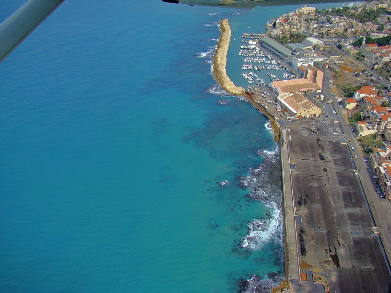
My first opportunity to do some aerial photography in Israel was with Ferrell Jenkins, as he and I were on a personal study trip in 2009. Among the sites we photographed from that (tiny) plane was biblical Joppa.

Aerial view of Joppa. Here the prophet Jonah boarded a ship in his escape attempt. Photo ©Leon Mauldin.

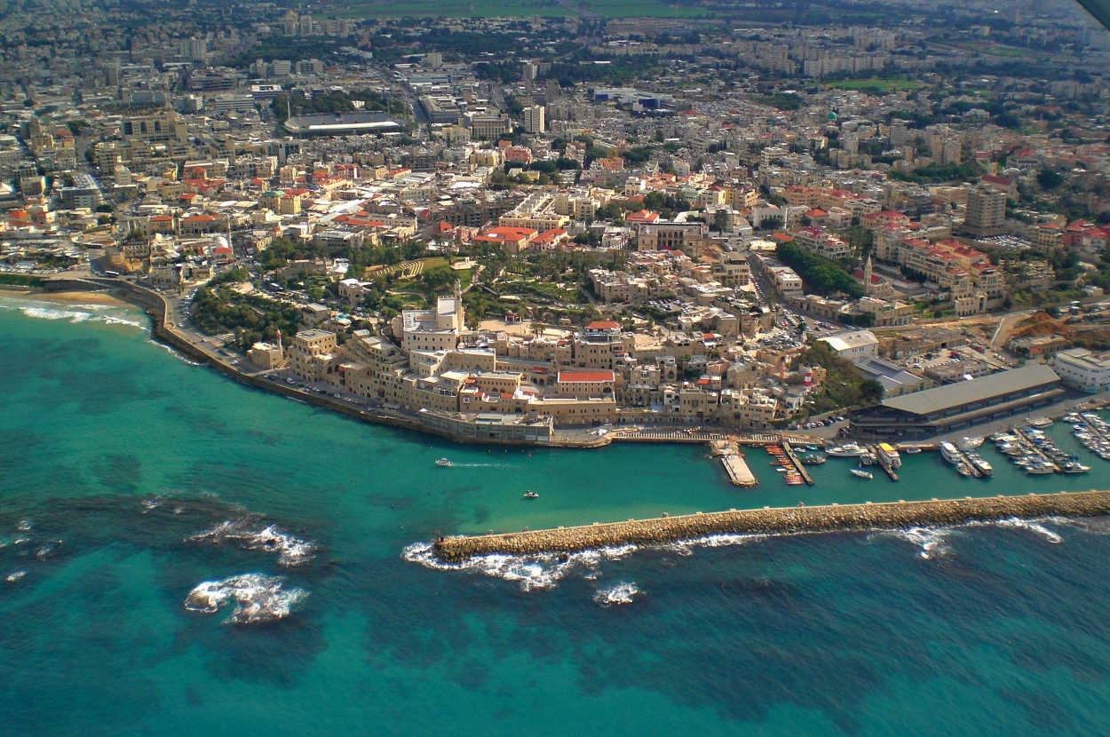
Here in the foreground you can still see some of the ruins of the ancient harbor, an ancient Mediterranean harbor of Canaan and Israel, dating back to Old Testament time. At center is the old city, the geographical setting for many biblical events:

When Solomon was to construct the temple, the king of Tyre offered,  “We will get all the timber you need from Lebanon and bring it in raft-like bundles by sea to Joppa. You can then haul it on up to Jerusalem.” (2 Chron. 2:16, NET).

Joppa was again used in this same manner when the second temple was rebuilt (Ezra 3:7). It’s about 35 miles from Joppa to Jerusalem.

Joppa figures in with the narrative of Jonah, who, when God told him to preach to Nineveh, “Instead, Jonah immediately headed off to Tarshish to escape from the commission of the LORD. He traveled to Joppa and found a merchant ship heading to Tarshish. So he paid the fare and went aboard it to go with them to Tarshish far away from the LORD” (Jonah 1:3, NET).

In NT times, there were disciples of Christ at Joppa. It was here that Peter raised Tabitha from the dead (Acts 9:36-43). Peter remained at Joppa for “many days” (Acts 9:43) and was there when the Gentile Cornelius, a Roman centurion stationed at Caesarea,  sent for him, that he could hear the Gospel message of salvation (Acts 10; 11:1-18; see esp. 11:14).

I visited Joppa for the first time in 1999. It gives a different perspective to see such sites from above.

Another view of Joppa, looking north. Photo ©Leon Mauldin.

Joppa is just to the south of the modern city of Tel Aviv.

Click photos for larger view.


Solomon Went to Elath

October 30, 2023

“Then Solomon went to Ezion Geber and Elath on the coast of Edom. And Hiram sent him ships commanded by his own officers, men who knew the sea. These, with Solomon’s men, sailed to Ophir and brought back four hundred and fifty talents of gold, which they delivered to King Solomon (2 Chronicles 8:17,18).

Let’s first get the geographical setting of Elath (also spelled Eloth, Eilat):

Map courtesy of biblemapper.com

The location of Elath was at the southern tip of the Arabah, and the north eastern tip of the Red Sea, at the Gulf of Aqaba. This allowed Solomon’s fleet of ships access to the Red Sea and of course, south from there into the Indian Ocean. It would seem that through this means of commerce the Queen of Sheba (see map inset) learned of Solomon, and made the journey to see for herself the incredible reports she had heard (related in the next chapter, 2 Chron. 9:1-12).

In March 2018, Ferrell Jenkins and I made a personal study trip which included this area. In this photo I am at Elath looking south.

At Elath, looking south. Photo ©Leon Mauldin.

Here we see a view showing some ships at Elath.

Ships in harbor at Elath. Photo ©Leon Mauldin.

B. S. Hummel has the following information regarding Elath:

A city and harbor at the head of the Gulf of Aqabah. Elath’s strategic position made it an important gateway for caravan and naval commerce with Arabia and eastern Africa. In the OT Elath is frequently placed in close proximity to Ezion-geber. Some scholars consider Tell el-Kheleifeh (147884), which lies between modern Elath and Aqabah, as Elath, others as Ezion-geber, and still others as the site for both Elath and Ezion-geber. The site was also known as El-paran (Gen. 14:6). The Ptolemies changed its name to Bernice.
Elath was originally Edomite, possibly taking its name from the Edomite chief Elah (Gen. 36:41 = 1 Chr. 1:52; Eloth). Toward the end of the Exodus, the Israelites passed through Elath before turning north toward Edom and Moab (Deut. 2:8). David probably captured it during his campaign against the Edomites (2 Sam. 8:13–14). Solomon then established a navy of ships in Ezion-geber near Elath (1 Kgs. 9:26 = 2 Chr. 8:17). Apparently the Edomites had regained control, but Uzziah (Azariah, 2 Kgs. 14:22; 2 Chr. 26:2) recaptured and restored it (ca. 780 B.C.). However, under Aramean (Syrian) pressure during the Syro-Ephraimite War (ca. 735), Ahaz lost it to the Edomites permanently (2 Kgs. 16:6).

Hummel, B. S. (2000). Elath. In D. N. Freedman, A. C. Myers, & A. B. Beck (Eds.), Eerdmans Dictionary of the Bible (p. 388). W.B. Eerdmans.

At Elath, looking east. We are of course in the Great Rift Valley here.

At Elath, looking at mountains to the east. Photo ©Leon Mauldin.

The Port of Elath/Eilat (Hebrew: נמל אילת) is the only Israeli port on the Red Sea.


At Biblical Elath, on the Red Sea

March 27, 2018

The past two days Ferrell Jenkins and I have explored various sites in the Arabah (see Deut. 1:1 & etc., NASB), using Elath (spellings vary) as our base. This evening I took a photo looking out to the Red Sea.

Looking out to the Red Sea from Elath. Photo by Leon Mauldin.

It was in this area that King Solomon stationed a fleet of ships: “King Solomon also built a fleet of ships at Ezion Geber, which is near Elath on the shore of the Red Sea, in the land of Edom” (1 Kings 9:26).  This was made possible through the cooperation of the Phoenicians. 2 Chronicles 8 records, “Then Solomon went to Ezion Geber and Elath on the seacoast, in the land of Edom. And Hiram sent him ships by the hand of his servants, and servants who knew the sea. They went with the servants of Solomon to Ophir, and acquired four hundred and fifty talents of gold from there, and brought it to King Solomon” (vv.17-18).

Note the location of Elath:

Location of Elath on the Red Sea. BibleAtlas.com.

Click images for larger view.


Hazor, One of Solomon’s Fortress Cities

February 13, 2016

1 Kings 9:15 reads, “Now this is the account of the forced labor which King Solomon levied to build the house of the LORD, his own house, the Millo, the wall of Jerusalem, Hazor, Megiddo, and Gezer.

During the time of pre-conquest Canaanite occupation, “Hazor formerly was the head of all these kingdoms” (Josh. 11:10), a reference to the city states of northern Canaan. It was located on the strategic Via Maris. This is a view of the tel:

Tel Hazor, one of the cities Solomon fortified. Photo by Leon Mauldin.

Tel Hazor, one of the cities Solomon fortified. Photo by Leon Mauldin.

I have previously written on Hazor here.

Click image for larger view.


Gezer

November 18, 2010

I’m currently attending the ETS and SBL meetings in Atlanta, and enjoying sharing a room with bro. Ferrell Jenkins.

A couple of the presentationstoday have been on biblical Gezer.  This city was given as a dowry to Solomon by Pharaoh when he married Pharaoh’s daughter.  Gezer became a fortress city, guarding access to the south. Excavation is ongoing.

Today’s post features an aerial photo of Gezer, taken last year (Dec. 2009).

Aerial photo of Gezer. Photo ©Leon Mauldin.

In the center of the photo you can see Gezer’s “standing stones.”  Upper right show an important area of excavation, including the six-chambered gate.


Gezer’s Defense Gate

March 28, 2010

Our previous post featured a photo of one of Gezer’s boundary stones.  We noted, “Excavations (1964–73) have uncovered a six-chambered gate and defenses” (NBD).  Pharaoh king of Egypt took Gezer from the Canaanites and gave it as dowry for his daughter, who became Solomon’s wife (1 Kings 9:16).  Because of its strategic location in the Shephelah in the south, Solomon made it a fortress city.  The six-chambered gate referenced in the NBD article was characteristic of Solomon’s other fortress cities, such as Hazor and Megiddo (both also strategically located).

This aerial photo shows the tel of Gezer from the south looking north.

Gezer Aerial Overview. Photo by Leon Mauldin.

In the right center in photo below you can see the 6-chambered  gate.

Gezer Aerial Detail. Photo by Leon Mauldin.

This shows the gate at ground level. You can see the central hill country in the background.

Gezer Six-Chambered Gate. Photo by Leon Mauldin.

Inside the gates there were benches where people could sit and visit, or carry on business transactions. In Dec. 2009 my friend and former professor Ferrell Jenkins and I visited the site.  This photo demonstrates the concept of “sitting at the gates” references in such passages as Gen. 19:1; 2 Sam. 19:8; Prov. 31:23, etc. Visit his blog at http://ferrelljenkins.wordpress.com/

Ferrell Jenkins at Gate at Gezer. Photo by Leon Mauldin.