The Cyrus Cylinder

March 20, 2021

“Who says of Cyrus, ‘He is My shepherd, And he shall perform all My pleasure, Saying to Jerusalem, “You shall be built,” And to the temple, “Your foundation shall be laid.” ‘ (Isa. 44:28)

I often say that every passage has a context; the greater context of our passage here, Isaiah 40-48, addresses the incomparable greatness of  YAHWEH. This is especially seen in these chapters as the true God is contrasted with the idols made by human hands. The gods created in the imaginations of men cannot see anything, or say anything, or do anything (cf. Isa. 44:9-20). But the God of Israel says,  “Thus says the LORD, the King of Israel, And his Redeemer, the LORD of hosts: ‘I am the First and I am the Last; Besides Me there is no God. And who can proclaim as I do? Then let him declare it and set it in order for Me, Since I appointed the ancient people. And the things that are coming and shall come, Let them show these to them.” (Isa. 44:6-7).

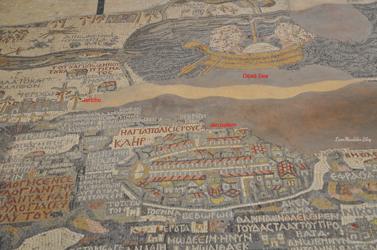
One manifestation of the true God’s great power is that only He can foretell the future. So while the Assyrians were still the world power, God foretold through Isaiah (8th century BC) that it would be Babylon who would take Judah captive (Isa. 39). Then God foretold the return from Babylonian captivity (Isa. 48:20). But through Isaiah (prophetic work spanned 740-ca.690 BC) God called the future deliverer by name: it would be Cyrus, king of the Persians (r. 559-530 BC). Approximately two centuries before Cyrus ascended the throne, God called him by name, and foretold that he would be the one who would allow the Jews to return from captivity and rebuild their temple! 

The Cyrus Cylinder. British Museum. Photo by Leon Mauldin.

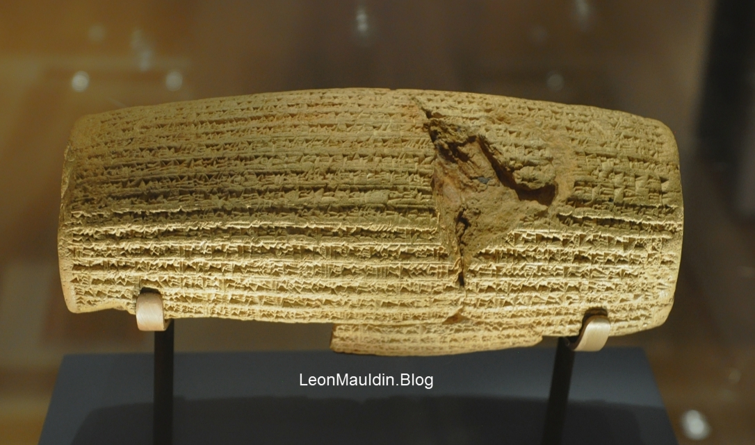
In addressing the significance of the Cyrus Cylinder, the Lexham Bible Dictionary notes:

The Cyrus Cylinder is an important piece of external evidence for the fall of the Neo-Babylonian Empire. Written in Akkadian, the Cylinder is a building inscription celebrating the restoration of Babylon, which Cyrus king of Persia conquered. The Bible records that Cyrus’ conquest brought an end to the Babylonian exile and allowed for the exiled Judahites to return to their homeland (Ezra 1:3; 2:1–67). The Cyrus Cylinder does not explicitly mention the Judahites, but the book of Ezra opens with a decree from Cyrus that allows the Judahites to return from exile and promises Persian patronage for the reconstruction of the temple in Jerusalem.

Krijgsman, M. (2016). Cyrus Cylinder. In J. D. Barry, D. Bomar, D. R. Brown, R. Klippenstein, D. Mangum, C. Sinclair Wolcott, … W. Widder (Eds.), The Lexham Bible Dictionary. Bellingham, WA: Lexham Press.

Note how this ties in with Ezra’s opening verses that tell of the decree of King Cyrus:

Now in the first year of Cyrus king of Persia, that the word of the LORD by the mouth of Jeremiah might be fulfilled, the LORD stirred up the spirit of Cyrus king of Persia, so that he made a proclamation throughout all his kingdom, and also put it in writing, saying, Thus says Cyrus king of Persia: All the kingdoms of the earth the LORD God of heaven has given me. And He has commanded me to build Him a house at Jerusalem which is in Judah. Who is among you of all His people? May his God be with him, and let him go up to Jerusalem which is in Judah, and build the house of the LORD God of Israel (He is God), which is in Jerusalem. And whoever is left in any place where he dwells, let the men of his place help him with silver and gold, with goods and livestock, besides the freewill offerings for the house of God which is in Jerusalem.

Ezra 1:1-4

Indeed, the true God proclaimed “the things that are coming and shall come”!


Madeba Map

March 12, 2021

The Madeba Map (also spelled Madaba/Medeba) is made of colored mosaics, located at Madeba east of the Dead Sea, in today’s Jordan. It is not far from Mount Nebo, which Moses ascended to view the Promised Land of Canaan prior to his death (Deut. 34). The map was excavated in 1896 in St. George’s church.

Madeba Map, St. George’s Church, Jordan. Photo ©Leon Mauldin.

From the Lexham Bible Dictionary:

One significant archaeological find in Madaba was the accidental discovery in the late 19th century of the sixth-century AD Madaba map, located in St. George’s church. The Madaba Map is a depiction of the Holy Land—with Jerusalem at its center (Donner, The Mosaic Map of Madaba)—and it explains how the Near East was perceived in the Byzantine period (AD 324–640). The map views the Near East from the vantage point of the Mediterranean Sea, and includes both Cisjordan and Transjordan. The Jordan River has often been thought of as a barrier between the territories west and east of the Jordan in both ancient and modern times. However, the Madaba Map was intended to be a record of the contemporary Near East in the sixth century, and it depicted it as a region whose cities—those on both the western and eastern sides of the Jordan River—were part of a shared culture.

Hawkins, R. K. (2016). Medeba. In J. D. Barry, D. Bomar, D. R. Brown, R. Klippenstein, D. Mangum, C. Sinclair Wolcott, … W. Widder (Eds.), The Lexham Bible Dictionary. Bellingham, WA: Lexham Press.

In our photo here, I have labeled at center Jerusalem, and above it, the Dead Sea. Jericho can be seen at left. Note the palm trees (cf. Deut. 34:3). The map is oriented east (instead of our usual north).

More info is available from BAR:

Cities, villages and topographical features of the Holy Land—many confirmed by recent archaeological discoveries—appear on this portion of the famous Madaba mosaic map. Discovered in 1884 on the floor of a sixth-century A.D. church in Madaba, Jordan (20 miles southwest of Amman), the fragment in the photograph is about half the extant portion of the map.
Details Outside Jerusalem
The Madaba map is a blend of whimsy, impressionistic rendering and precise attention to detail. Because the map is oriented with east at the top, the Jordan River flows horizontally from left to right into the Dead Sea. In the sea, two boats bearing sailors (only some hands and feet remain from the original mosaic) float high on the turbulent water. Several fish are swimming in the Jordan River. A fish at the southern end of the river seems to swim deliberately away from the sea after having tasted the heavy salt content in the water. Above the Dead Sea, the steep mountains of Moab are depicted in pink and yellow on their lower arid slopes and gray-green on their more fertile upper reaches.
The Madaba map identifies Biblical events and places in its Greek text and also represents and names many of the physical features of the Holy Land during the late Byzantine period. Large red letters designate areas allotted to the tribes of Israel. On the far right is the word “Judah”; the large red letters at the bottom center are part of the phrase “[Lot] of Dan.” Historical notes and quotations from the Septuagint, a third-century B.C. Greek translation of the Hebrew Bible, appear in many places on the map (The red letters on the yellow background in the lower left corner of the map [part of the territory of Ephraim] read “Joseph ‘God shall bless thee with the blessing of the deep that lieth under’ and again ‘Blessed of the Lord be his land’” [Genesis 49:25, Deuteronomy 33:13].)
Most of the Biblical site identifications on the map are based on the Onomasticon, a fourth-century Biblical geography written by the Christian scholar Eusebius, but the artist who produced the Madaba map was aware of other traditions as well. For example, Mount Ebal and Mount Gerizim appear twice, once near Jericho, where Eusebius placed them, and again in Aramaic, on either side of the Shechem plain, where Samaritan tradition placed them.
Awareness of local details is seen in the representation of a small boat, probably a ferry, attached to a crossing rope extending from one side to the other of the Jordan River (far left), and most notably in the representation of Jerusalem (in the center of the map).


Jerusalem Details
The importance accorded Jerusalem is indicated by its size; although the map was not produced to an exact scale, Jerusalem is portrayed at a scale approximately ten times larger than the scale of the rest of the map. The drawing shows Jerusalem, as though seen from the air, looking toward the east. However, the mosaic artist took liberties and sometimes showed the eastern, northern, or southern facade of various buildings and gates.
On the north side of the city is the main gate (1), opening onto an oval plaza, in the center of which is a column, probably constructed by a Roman emperor, whose statue may once have stood atop the column, but in the sixth century it was long gone. Today the northern gate is popularly called the Damascus Gate, but the memory of the ancient column is preserved in the Arabic name of the gate, which means “Gate of the Column.”
Running north south (horizontally) away from the oval plaza is the main street of sixth-century Jerusalem, the cardo . The colonnades along this street are shown as rows of columns, covered by red roofs, flanking the central roadway.
The depiction of the cardo is interruption in the middle on the western (bottom) side by four white steps leading to the eastern facade of the red-roofed Church of the Holy Sepulchre. (In the Madaba map red-roofed buildings are usually churches or monasteries; yellow- or gray-roofed buildings are palaces or public buildings, and brown areas are public squares.) The Church of the Holy Sepulchre appears to be upside down. Three doors appear in the church’s facade (below the steps). Below the facade is a triangular pediment and below the pediment, the church’s roof. A. row of dark-colored tiles represents the courtyard that separated the basilica of the church from the rotunda (shown on the map by a gold semicircle). The golden dome of the rotunda stood over the traditional site of the tomb of Jesus, with its red roof and double doors facing west.
At the southeastern end of the cardo is another famous church, the Nea, built by the emperor Justinian in the sixth century and dedicated in 542; the Madaba map was probably produced about 20 years later. The large red-roofed building with conspicuous yellow gates south of the cardo is one of the principal sanctuaries in Byzantine Jerusalem, a basilica on Mt. Zion called the “Mother of All the Churches.”
On the western side of the city is the Jaffa Gate. A street, the decumanus, runs due east from the gate and intersects the cardo. A north-south street intersects the decumanus at right angles and parallels the cardo. The Armenian Street in modern Jerusalem follows the line of the street that ran parallel to the cardo.
The curving, colonnaded street in the eastern part of Jerusalem was located where the street known as Tariq el Wad is today. This street runs along the Tyropoean Valley from the Damascus Gate to the Dung Gate. To the east of the Tariq el Wad is the Temple Mount; to the west, the Upper City.
The Temple Mount is difficult to identify on the Madaba map. No buildings were located on the Temple Mount in sixth-century Jerusalem. The black line above the row of columns in the upper right may have been intended to represent the Temple Mount. The three parallel bands to the right of this dark line are interpreted as either the bridge connecting the Upper City with the Temple Mount, incorporating the arch called today “Wilson’s” Arch, or as a portion of the Western or “Wailing” Wall—part of the retaining wall of the Temple Mount platform. Beginning in the fourth century, Jews were allowed to enter Jerusalem once a year on the ninth day of the month of Ab to commemorate the destruction of the Temple. It is likely that the site of their annual mourning service occurred at the wall represented here on the sixth-century Madaba map.
The Golden Gate. which opens onto the Temple Mount, is shown in the eastern wall of the city. The name of the other large gate in the eastern wall is not known; many pilgrims to Jerusalem referred to this other gate simply as “the eastern gate.”

(1983). BAR, 9(6).

Biblical references to Madeba include Numbers 21:30, Joshua 13:9,16, 1 Chronicles 19:7 and Isaiah 15:2.


Board Games: Royal Game of Ur

March 9, 2021

According to the British Museum:

The Royal Game of Ur is the oldest playable boardgame in the world, originating around 4,600 years ago in ancient Mesopotamia.

The game’s rules were written on a cuneiform tablet by a Babylonian astronomer in 177 BC. From this, curator Irving Finkel was able to decipher the rules – two players compete to race their pieces from one end of the board to the other. The central squares were also used for fortune telling.

https://blog.britishmuseum.org/top-10-historical-board-games/

This game-piece is dated to 2600 BC, consisting of inlaid shell and lapis lazuli, and is among the many artifacts excavated by Sir Leonard Wooley, in the Royal Cemetery of Ur, located in today’s southern Iraq. It is said to be similar to backgammon. The British Museum even provides a YouTube video on how to play. Click here.

The Royal Game of Ur, British Museum. Photo ©Leon Mauldin.

Status Symbol? An article in BAS article suggests the following:

In the ancient world, board games, one of the world’s oldest hobbies, were played not only to pass the time, but also to signify the wealth and status of the players, according to a new study. Mark Hall, an historian with the Perth Museum and Art Gallery in Scotland, believes the process by which board games spread across the ancient world suggests they were passed along as elite gifts. “Many of the first board games appear to have been diplomatic gifts to signify status,” said Hall. “We have early examples of quite splendid playing pieces belonging to elite, privileged people.” Hall notes that many of the earliest board games from the ancient Near East, including the Mesopotamian game of Twenty Squares (similar to today’s backgammon) and the Egyptian game of Senet (which used a grid of 30 squares), were discovered as offerings or gifts in royal burials, such as the Royal Tombs of Ur and the tomb of King Tutankhamen.

https://www.biblicalarchaeology.org/daily/ancient-cultures/daily-life-and-practice/board-games-were-status-symbols-in-the-ancient-world/

Sir Leonard Woolley directed 12 seasons of excavations at the site of ancient Ur (Tell el-Mukay-yar) on behalf of the British Museum and the University of Pennsylvania.

Students of the Bible have an interest in Ur of the Chaldees as the home of the patriarch Abraham (Gen. 11:28,31; Neh. 9:6). Not all agree that Woolley was correct in his identification, but his excavations there are informative and fascinating, to say the least.


Sennacherib: a Pagan King vs. יהוה

March 5, 2021

The record of the pagan Assyrian king Sennacherib, who challenged יהוה, the LORD God of Israel, is found in three biblical texts: 2 Kings 18-19, 2 Chronicles 32 and Isaiah 37. The year was 701 BC. Israel to the north had already fallen to the Assyrians (722 BC). Now (at the time referenced in the above texts) only tiny Judah remained, with its King Hezekiah. At this point Sennacherib had taken forty-six fortified cities of Judah, lastly Lachish, and then came to Jerusalem “with a great army” (Isa. 36:2).

Sennacherib sent the Rabshakeh with the message to Jerusalem, who shouted out in Hebrew, “Hear the word of the great king, the king of Assyria. Thus says the king, Do not let Hezekiah deceive you, for he will not be able to deliver you from my hand; nor let Hezekiah make you trust in the LORD, saying, The LORD will surely deliver us, and this city will not be given into the hand of the king of Assyria.” Then it got worse: “But do not listen to Hezekiah when he misleads you, saying, The LORD will deliver us. Has any one of the gods of the nations delivered his land from the hand of the king of Assyria? Where are the gods of Hamath and Arpad? Where are the gods of Sepharvaim, Hena and Ivvah? Have they delivered Samaria from my hand? Who among all the gods of the lands have delivered their land from my hand, that the LORD should deliver Jerusalem from my hand?” (2 Kings 18:28-30; 32-35).

Hezekiah went to the house of God. He sent for the prophet Isaiah with the request, “Lift up your prayer for the remnant that is left” (2 Kings 19:4). The Lord’s answer: “Whom have you reproached and blasphemed? And against whom have you raised your voice And haughtily lifted up your eyes? Against the Holy One of Israel!” (Isa. 37:23). Further: “Therefore, thus says the LORD concerning the king of Assyria, He will not come to this city or shoot an arrow there; and he will not come before it with a shield, or throw up a siege ramp against it. By the way that he came, by the same he will return, and he will not come to this city, declares the LORD. For I will defend this city to save it for My own sake and for My servant David’s sake. Then the angel of the LORD went out and struck 185,000 in the camp of the Assyrians; and when men arose early in the morning, behold, all of these were dead. So Sennacherib king of Assyria departed and returned home and lived at Nineveh” (vv. 33-37).

One of the fascinating artifacts housed in the British Museum is Sennacherib’s Prism, otherwise known as Taylor’s Prism, named after the one who discovered it. This is King Sennacherib’s account of his victories. He specifically mentions Hezekiah, and the Assyrian siege of Jerusalem.

Sennacherib’s Prism, British Museum. Photo by Leon Mauldin.

The text is in Akkadian Cuneiform, the international language of the time. The reference to Hezekiah reads, “

As for Hezekiah, the Judean, I besieged forty-six of his fortified walled cities and surrounding smaller towns, which were without number. Using packed-down ramps and applying battering rams, infantry attacks by mines, breeches, and siege machines, I conquered (them). I took out 200,150 people, young and old, male and female, horses, mules, donkeys, camels, cattle, and sheep, without number, and counted them as spoil. He himself, I locked up within Jerusalem, his royal city, like a bird in a cage.

(Hallo, W. W., & Younger, K. L. (2000). Context of Scripture: Monumental Inscriptions from the Biblical World (p. 303). Leiden; Boston: Brill).

Sennacherib fails to mention why he did not take Jerusalem. He fails to mentions that 185,000 of his Assyrian soldiers died in one night. Why would he say only that he had Hezekiah locked up “like a bird in a cage,” but then fail to go on to record Jerusalem’s capture and that of its king? There can be only one explanation; he failed to do so, just as the Bible says. It is a case when the silence of the Assyrian record speaks volumes. This is after all, the same king who at his palace in Nineveh memorialized his conquest of Lachish with numerous carved stone wall panels which include graphic portrayals of the ramp and siege machines, also housed in the British Museum. But the pagan king did not fare so well when he challenged the LORD, the God of Israel.


%d bloggers like this: