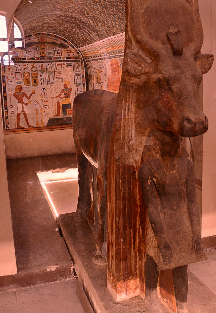
As we continue to explore some of the displays in the Egyptian Museum in Cairo, we look at the shrine dedicated by Tutmosis III to the goddess Hathor at Deir-el-Bahari.
The goddess Hathor appears here in the form of a cow. This was excavated between the temples of Mentuhotep and Hatshepsut by E. Naville, of the Egypt Exploration Fund, 1906, and dates to the 18th dynasty (New Kingdom), at the end of the reign of Tutmosis III (c. 1504-1450) and the beginning of the reign of Amenophis II (c. 1453-1409).
The painting in the back shows Tutmosis III (left) pouring a libation and burning incense to Amon-Re, seated (at right). The dark blue vaulted ceiling depicts the stars of heaven.
The cult of the Sacred Cow was long associated with Hathor, the goddess of the Theban necropolis. Hatshepsut dedicated her sanctuary to the goddess. Prior to its excavation, earthquakes had buried the entrance to the chapel of the Sacred Cow.
The statue of the sacred cow in our photo bears the name of Tutmosis’s successor, Amenophis II. He is here depicted as crouching beneath the head of the sculpture. Hathor is surrounded by papyrus stems. She wears the Hathoric horns with the sun disk and a uraeus serpent on her forehead.
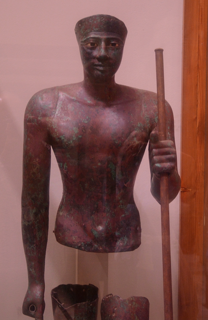
Excavations at the temple of Horus at Hierakonpolis (ancient Nekhen) on the west bank of the Nile (north of Aswan, and south of Edfu), produced some remarkable finds, including a hollow-cast copper statue of Pepi I.
Pepi I had a lengthy reign of about 50 years (c. 2283-2287 BC). His reign is in Dynasty 6, Old Kingdom. Numerous inscriptions record his influence and wealth.
“It is from Pepi’s funerary monument that the modern name of Memphis derives. His pyramid was called Mn-nfr, ‘[Pepi is] established and good'” (Clayton, Chronicles of the Pharaohs, p. 66).
To keep things interesting, Pepi married two daughters of a provincial prince of Abydos who both had the same name, Ankhnesmerire.
Pepi’s pyramid is at South Saqqara, and is badly smashed.
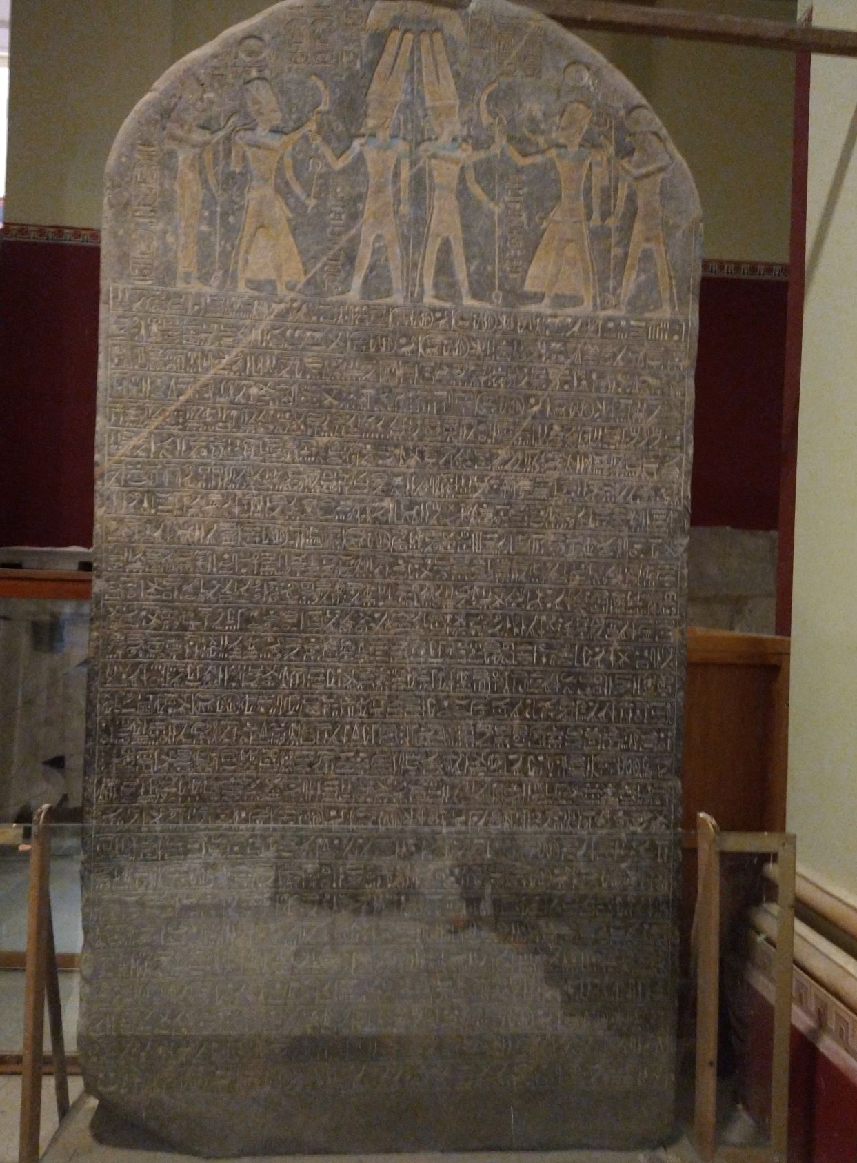
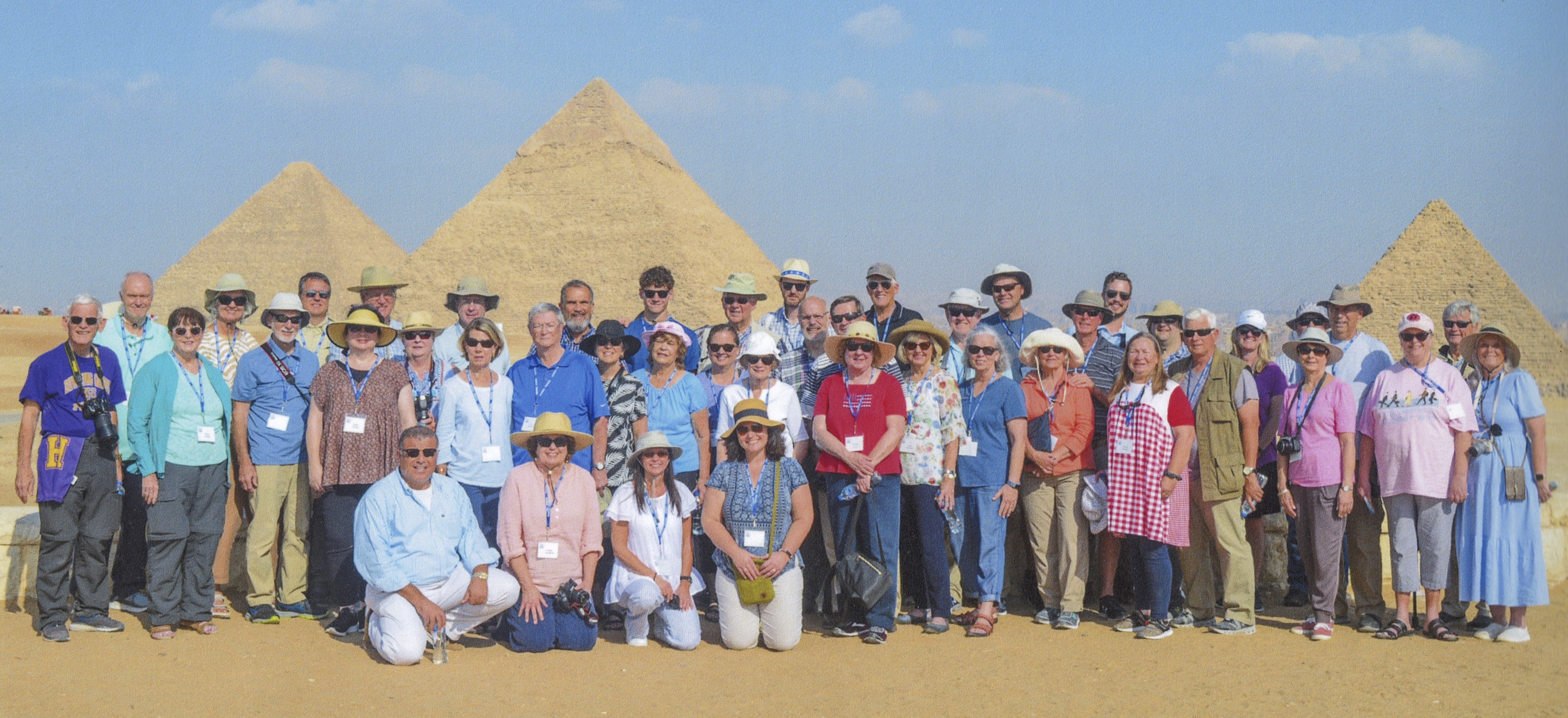
Merneptah, son of Rameses II, ruled Egypt 1213-1203 B.C., in the 19th Dynasty. The Merneptah Stele, made of granit, is an inscription of great archaeological and biblical importance. It contains the first mention of Israel in a source besides the Bible. On our recent tour of Egypt, this is one of the main artifacts I wanted our group to see and photograph while visiting the Egyptian Museum in Cairo.
The stele was discovered in 1896 at Thebes by F. Petrie in 1896. It is 7.5 feet high, and made of black granite. It is displayed now in the Egyptian Museum at Cairo. The inscription includes the lines:
The princes, prostrated, say "Shalom";
None raises his head among the Nine Bows,
Now that Tenhenu has come to ruin, Hatti is pacified.
Canaan has been plundered into every sort of woe. Ashkelon
has been overcome.
Gezer has been captured.
Yano'am was made non-existent.
Israel is laid waste (and) his seed is not.
Hurru has become a widow because of Egypt.
All lands have united themselves in peace.
Anyone who was restless, he has been subdued by the King
of Upper and Lower Egypt, Ba-en-Re-mery-Amun, son
of Re, Mer-ne Ptah Hotep-her-Ma'at, granted life like
Re, daily. (Frank Yurco, BAR, 16:05, Sept/Oct 1990)
The date of this inscription would be about 1207 B.C. By that point in time, Israel was established in the land of Canaan to such an extent that it would be included in a listing of nations defeated by the world’s most powerful monarch.
Many “scholars” deny that Israel even existed as a nation by this point in time, but the inscription proves them to be wrong.
For further reading I recommend Todd Bolen’s article in The Bible and Interpretation. Go to:
At the top of the stele there are two engraved scenes in which Pharaoh Merneptah is wearing ceremonial dress and offers Amun-Ra the reaping hook that symbolized victory and scepters of royalty. In the first scene Merneptah is followed by the goddess ut and in the second by the god Khonsu. Both were members of the Theban triads of gods with Amun-Ra.
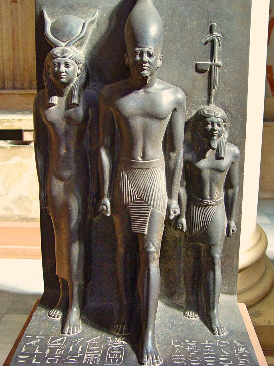
Pharaoh Menkaura/Mycerinus was the builder of the 3rd pyramid at Giza, Egypt. The triad of Menkaura represents the Pharaoh at center, wearing the white crown of Upper Egypt. To his right is the goddess Hathor. To his left is Waset representing the 4th Nome of Upper Egypt). This rendering is from a single block of stone. More statues survive of Menkaure than those of his 4th Dynasty predecessors.
At left can be seen a portion of the pyramid of Cheops. To the far right are three subsidiary pyramids. Menkaure’s chief queen, Khamerernebty II, was entombed in the larger of the three.
And to close this post, a photo of my wife & me:
In the background can be seen from left to right, the pyramid of Cheops, Chephren and Menkaure.
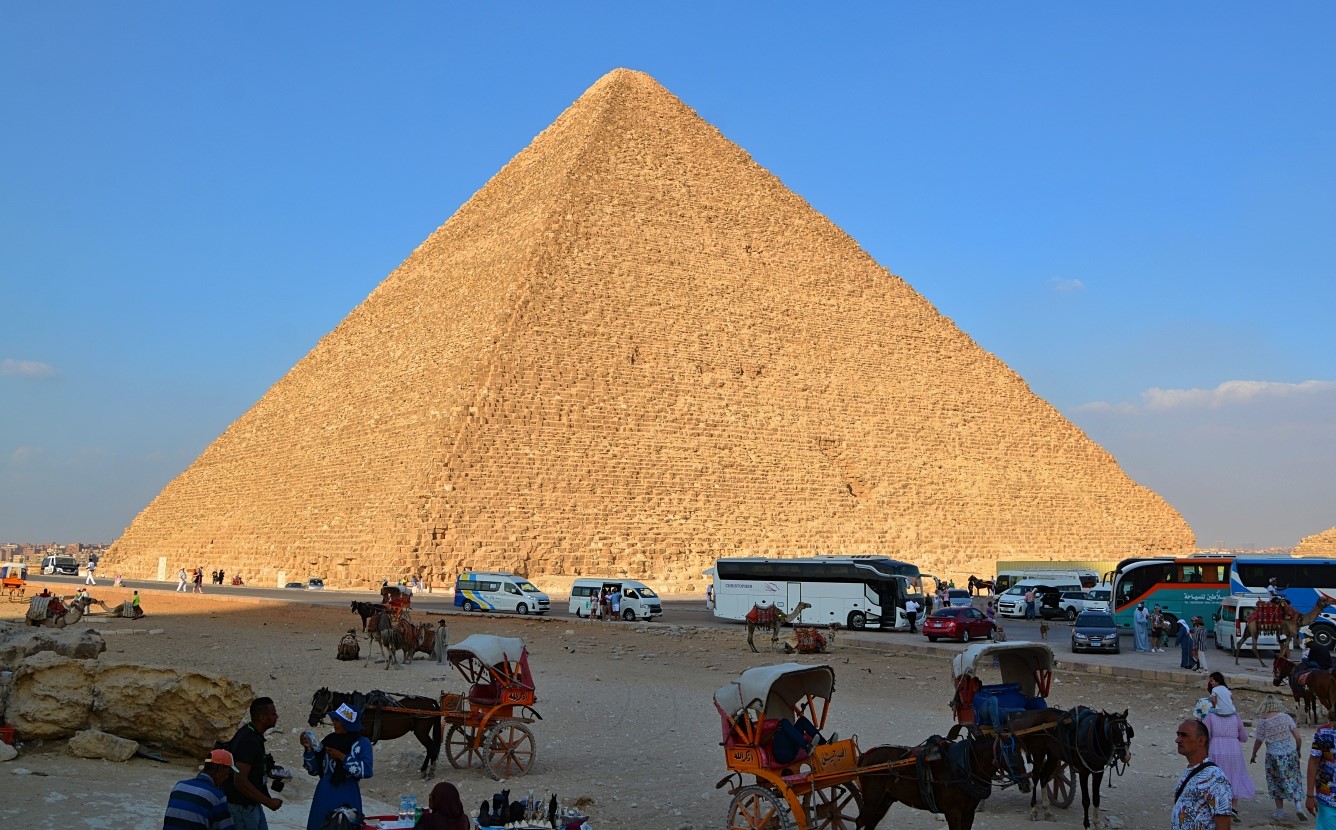
Egypt’s 4th Dynasty was founded by Snefru c. 2613 BC. His son Cheops (Khufu) succeeded him, and is the builder of the largest of the great pyramids, one of the Seven Wonders of the Ancient World.
Cheops’s reign is dated c. 2589-2566 BC. This tiny statue depicts the king wearing the crown of Lower Egypt. This artifact was discovered by Flinders Petrie in the Osiris temple at Abydos in 1903. “In a curious inverse ratio we find that the smallest statue represents the builder of the greatest pyramid, while some of the finest multiple statues extant from the Old Kingdom represent the builder of the smallest of the Giza pyramids, Menkaure (fifth ruler of the 4th Dynasty)” (Chronicles, Clayton, p. 49.
Cheops’s Great Pyramid is located on the Giza plateau. Originally reaching 481 feet, it was the tallest building in the world until the 19th century AD, an architectural record that stood for 4 1/2 thousand years. There are said to be 2,300,000 building blocks averaging about 2 1/2 tons.
At far left you can see the Great Pyramid of Cheops. At left center you see the pyramid of Chephren (Khafra/Khafre), which appears to be taller, but is in fact on higher ground. At far right is the pyramid of Mycerinus.
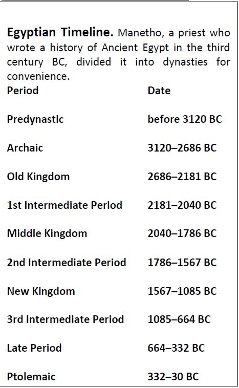
In this post we will give consideration to the first of the pyramid Builders, in the context of Egypt’s Old Kingdom (2686-2181 BC). For your convenience we share the following chart (keep in mind that dates are approximate and may vary):
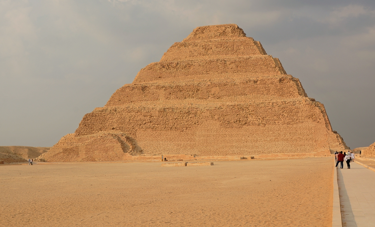
“Djoser’s pyramid and its surrounding mortuary complex is recognized as the first stone building in the world” (Chronicles of the Pharaoh’s, by Peter Clayton, p. 33), built by his vizier, Imhotep. Though begun “as a simple tomb, the structure was enlarged in height and breadth on five occasions, eventually rising to its present 197 feet. Unlike Egypt’s other pyramids, the Step Pyramid was built with comparatively small limestone blocks” (BAR Nov/Dec 1990, Richard Nowitz).
The pyramid, known as the Step Pyramid, began as a mastaba (an ancient Egyptian tomb rectangular in shape with sloping sides and a flat roof) “but was subsequently subject to several major enlargements, adding one mastaba upon another, until it consisted of six unequal steps rising t to 204 ft 962 m). Its base area is 358 X 411 ft (109 X 125 m)” (Clayton, p. 34).
The statue was found in a small chapel on the north face of the pyramid.
We should note that many have the mistaken notion that the Israelites were used as slave labor to build the pyramids. The pyramids were built some centuries before Israel came into being. They were built prior to the time of Abraham!
I have received the Photo Companion to the Bible on 1 & 2 Kings, from Dr. Todd Bolen. This is a portion of scripture on which I’m currently focused in study and writing, so it is a very welcome resource to me personally. I’ve made use of the BiblePlaces library for almost 20 years now, and am glad to highly recommend this most recent addition. More info and how to order is found here: https://www.bibleplaces.com/june-2022-newsletter/
The Books of Kings has long been an area of specialized study for Dr. Bolen, as explained in his newsletter.
This new resource has PowerPoint presentations on all 47 chapters of 1 & 2 Kings, with more than 7,400 slides! But this is not just a collection of photos–the descriptive text and explanatory notes are most helpful.
This type of resource is most helpful in giving the text of scripture its cultural and geographical context, and thus enhancing ones understanding of the Bible.
Thanks to Dr. Bolen and his colleagues for yet another great resource in this series!
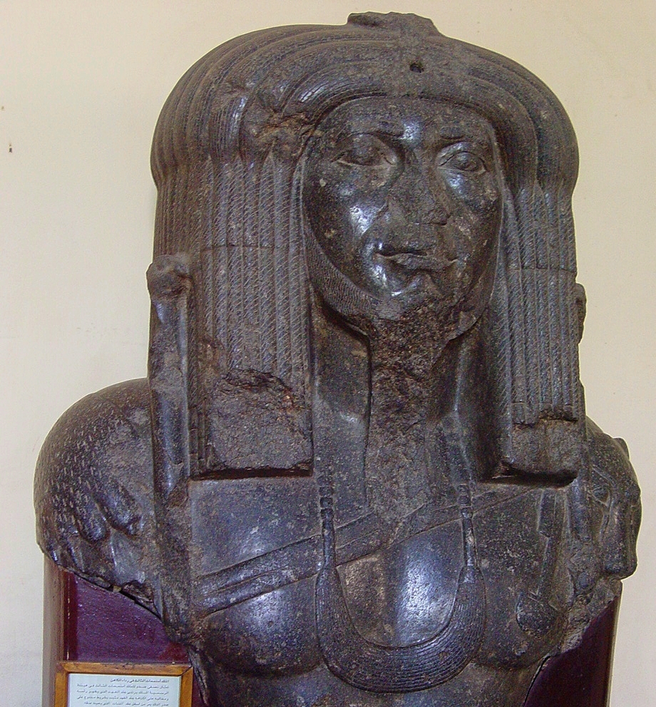
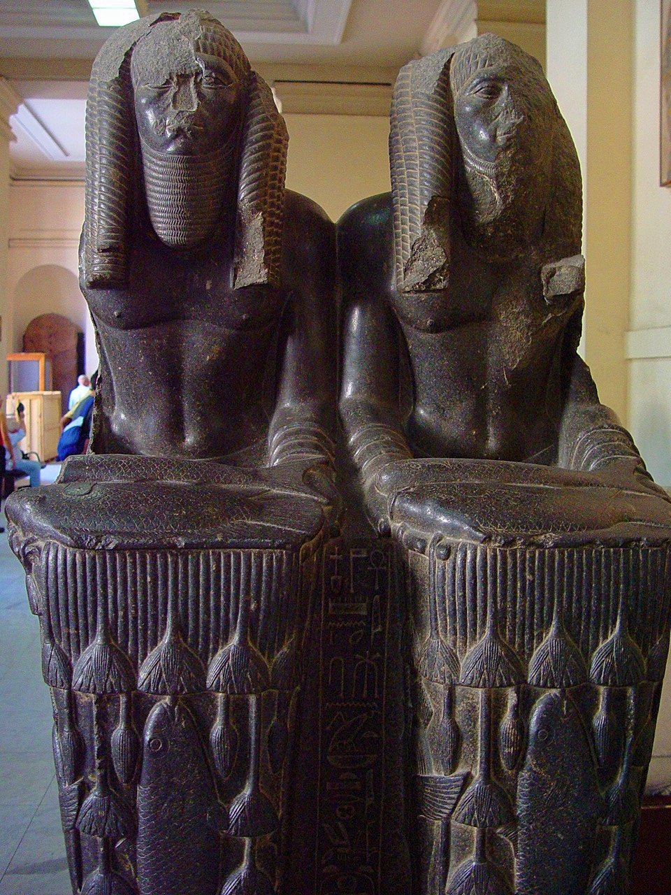
In our previous post we featured the Sphinx of Amenemhat III (ca. 1859-1813), who ruled during the time of the biblical patriarchs. This unique colossal bust of Amenemhat III was found on the site of the ancient capital of The Fayum, Shedet (the Crocodilopolis of the Greeks). The Pharaoh is dressed in a panther skin, with its head and paws lying on the king’s shoulders. A double band across his chest passes under the menat collar worn about his neck. The upper portion of two scepters terminating in falcon heads are visible on each side of his head.
In this double statue, Amenemhat III is represented as the Nile god bearing all the nourishment indispensable to life. One explanation of the doubling of the king is that the two figures represent him as ruler of both Upper and Lower Egypt. Others suggest that one image depicts the reigning king and the other his deified counterpart.
During his long reign, Amenemhet III had almost continual turquoise mining expeditions in the Sinai. More than fifty rock inscriptions have been found there referencing this. He was the last great ruler of the Middle Kingdom.
The Egyptian Museum in Cairo displays the sphinx of King Amenemhet III, who ruled in the Middle Kingdom, 12th dynasty. This is one of seven sphinxes of Amenemhat III that were found in Tanis in the eastern Delta.
The sphinx has the head of the king and the body of a lion, symbolizing the vitality and power of the pharaoh.
Amenemhet III reigned for 45 years (ca. 1859-1813 BC), which included a long coregency with his father Sesostris III. Dr. Douglas Petrovich states:
The major project of his reign was the reclamation of more arable land in the Fayyum by manipulating the water level of Lake Moeris, which led to his veneration in the Fayyum. His long and peaceful reign is viewed as the time when the MK [Middle Kingdom] reached its cultural peak. He also strengthened the border at Semna and enlarged some of the fortresses, in addition to constructing a large temple to Sobek at the site of Crocodilopolis, in the Fayyum.
(Origins of the Hebrews, p. 13).
Petrovich identifies Sesostris III (ca. 1878-1840 BC) as the pharaoh of the famine at the time Joseph (Ibid., 29). The patriarch Jacob’s death is dated as 1859 BC (Ibid., cf. Andrew E. Steinmann, From Abraham to Paul, p. 74). “Amenemhet III ascended the throne as coregent with his father in ca. 1860/59 BC, which took place either just before so soon after Jacob’s death” (Petrovich, 29).
“Who says of Cyrus, ‘He is My shepherd, And he shall perform all My pleasure, Saying to Jerusalem, “You shall be built,” And to the temple, “Your foundation shall be laid.” ‘ (Isa. 44:28)
I often say that every passage has a context; the greater context of our passage here, Isaiah 40-48, addresses the incomparable greatness of YAHWEH. This is especially seen in these chapters as the true God is contrasted with the idols made by human hands. The gods created in the imaginations of men cannot see anything, or say anything, or do anything (cf. Isa. 44:9-20). But the God of Israel says, “Thus says the LORD, the King of Israel, And his Redeemer, the LORD of hosts: ‘I am the First and I am the Last; Besides Me there is no God. And who can proclaim as I do? Then let him declare it and set it in order for Me, Since I appointed the ancient people. And the things that are coming and shall come, Let them show these to them.” (Isa. 44:6-7).
One manifestation of the true God’s great power is that only He can foretell the future. So while the Assyrians were still the world power, God foretold through Isaiah (8th century BC) that it would be Babylon who would take Judah captive (Isa. 39). Then God foretold the return from Babylonian captivity (Isa. 48:20). But through Isaiah (prophetic work spanned 740-ca.690 BC) God called the future deliverer by name: it would be Cyrus, king of the Persians (r. 559-530 BC). Approximately two centuries before Cyrus ascended the throne, God called him by name, and foretold that he would be the one who would allow the Jews to return from captivity and rebuild their temple!
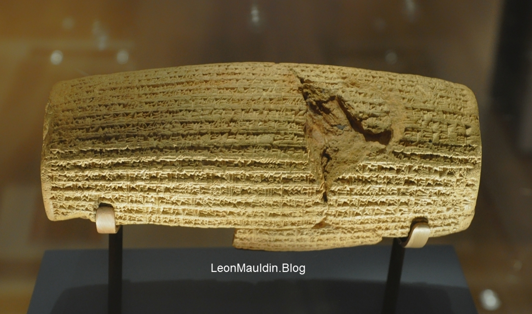
The Cyrus Cylinder. British Museum. Photo by Leon Mauldin.
In addressing the significance of the Cyrus Cylinder, the Lexham Bible Dictionary notes:
The Cyrus Cylinder is an important piece of external evidence for the fall of the Neo-Babylonian Empire. Written in Akkadian, the Cylinder is a building inscription celebrating the restoration of Babylon, which Cyrus king of Persia conquered. The Bible records that Cyrus’ conquest brought an end to the Babylonian exile and allowed for the exiled Judahites to return to their homeland (Ezra 1:3; 2:1–67). The Cyrus Cylinder does not explicitly mention the Judahites, but the book of Ezra opens with a decree from Cyrus that allows the Judahites to return from exile and promises Persian patronage for the reconstruction of the temple in Jerusalem.
Krijgsman, M. (2016). Cyrus Cylinder. In J. D. Barry, D. Bomar, D. R. Brown, R. Klippenstein, D. Mangum, C. Sinclair Wolcott, … W. Widder (Eds.), The Lexham Bible Dictionary. Bellingham, WA: Lexham Press.
Note how this ties in with Ezra’s opening verses that tell of the decree of King Cyrus:
Now in the first year of Cyrus king of Persia, that the word of the LORD by the mouth of Jeremiah might be fulfilled, the LORD stirred up the spirit of Cyrus king of Persia, so that he made a proclamation throughout all his kingdom, and also put it in writing, saying, Thus says Cyrus king of Persia: All the kingdoms of the earth the LORD God of heaven has given me. And He has commanded me to build Him a house at Jerusalem which is in Judah. Who is among you of all His people? May his God be with him, and let him go up to Jerusalem which is in Judah, and build the house of the LORD God of Israel (He is God), which is in Jerusalem. And whoever is left in any place where he dwells, let the men of his place help him with silver and gold, with goods and livestock, besides the freewill offerings for the house of God which is in Jerusalem.
Ezra 1:1-4
Indeed, the true God proclaimed “the things that are coming and shall come”!


 Posted by Leon Mauldin