Reading recently in Deuteronomy I came across the following text: “When you build a new house, you shall make a parapet for your roof, that you may not bring the guilt of blood upon your house, if anyone should fall from it” (22:8, ESV). The NET renders, “guard rail.”
It would be difficult to understand the meaning of that passage if we only read through 21st century eyes. The roof on my house is steep. It is much too steep for me to consider walking on it, or anybody else for that matter, except for roofers or repair men. There is no need for me to put a guard rail around my roof.
But roofs in biblical times were generally different (both Old and New Testament), being flat, and serving as a sort of “patio” or additional room. This is illustrated by the reconstructed two-story Talmudic house at Katzrin in the Golan:
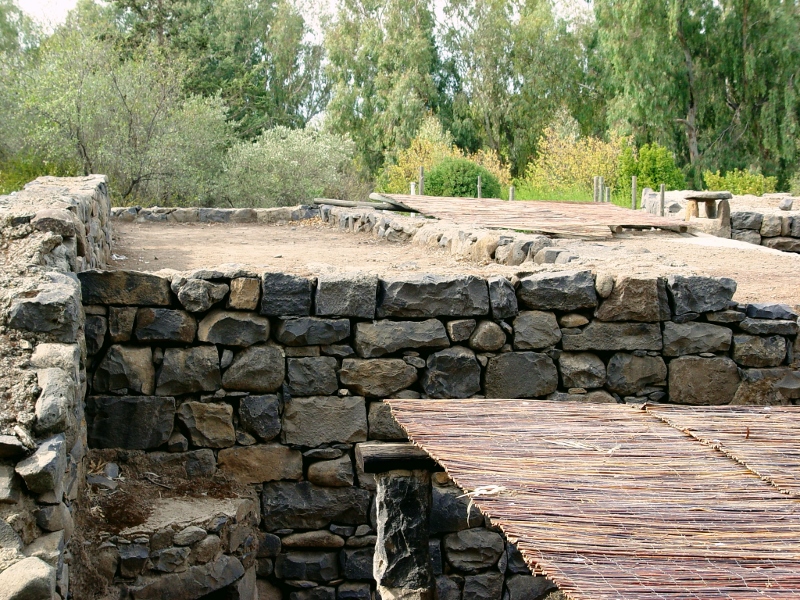
Housetop at Katzrin in the Golan. Photo by Leon Mauldin.
It is not hard to visualize how several people might be on a housetop such as this. I might note that the above photo does not have a guard rail around the housetop, but does illustrate the need for one and the practical nature of the command in the Deuteronomy text.
Understanding this can make several biblical texts come alive:
Proverbs 21:9 It is better to live on a corner of the housetop than in a house in company with a quarrelsome wife.
Looking ahead to the Roman destruction of Jerusalem, Jesus said, “Whoever is on the housetop must not go down to get the things out that are in his house” (Matt. 24:17).
Acts 10:9: “On the next day, as they were on their way and approaching the city, Peter went up on the housetop about the sixth hour to pray.” Context: Men from Cornelius of Caesarea sent down the coast to Joppa where Peter was residing, to ask him to come to Caesarea to preach the Gospel there.
Click image for larger view.
We have previously posted on Katzrin here.


 Posted by Leon Mauldin