The Suez Canal

November 10, 2017

On most Friday afternoons I teach some homeschoolers (brilliant students) two subjects, Bible and History. Currently their world history is dealing with the 19th century. One of the topics in that time-frame is the construction of the Suez Canal. Said Pasha  gave a concession to Ferdinand de Lesseps who created a French company, The Suez Canal Company, to join the Mediterranean Sea with the Red Sea. The canal opened under French control on November 17, 1869. (Said was Wāli of Egypt and Sudan from 1854 until 1863, officially owing allegiance to the Ottoman Sultan but in practice exercising virtual independence. 4th son of Muhammad Ali Pasha).

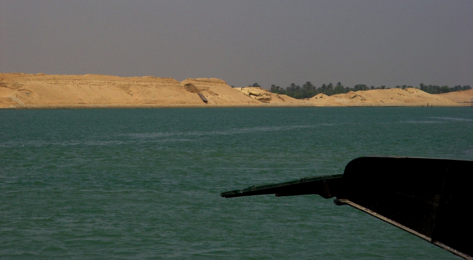
The Suez Canal. The Sinai Peninsula is at our back, looking across to Egypt. Photo ©Leon Mauldin.

Our text says:

Naturally, the countries of Europe were very interested in this canal–the Suez Canal. The canal could change the way that European countries traded with China, Japan, and the other countries of the Far East. Instead of travelling all the way down the coast of Africa, around the tip of that enormous continent, and then heading east, European ships could sail from the Mediterranean Sea straight down into the Red Sea and then turn east. When the canal was finished,it would be a hundred miles long, about twenty-six feet deep, and it would make the trip from Europe to the  East six thousand miles shorter! (The Story of the World: History for the Classical Child. Vol.4, p. 109).

This area is of tremendous biblical importance as it pertains to Israel’s crossing of the Red Sea en route to the promised land of Canaan. I have previously written here and here on the Suez.

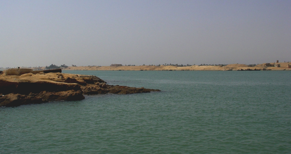
Another view of the Suez. Photo ©Leon Mauldin.

The canal separates the African continent from Asia, and it provides the shortest maritime route between Europe and the lands lying around the Indian and western Pacific oceans. It is one of the world’s most heavily used shipping lanes. The Suez Canal is one of the most important waterways in the world.

The canal is extensively used by modern ships , as it is the fastest crossing from the Atlantic Ocean to the Indian Ocean . Tolls paid by the vessels represent an important source of income for the Egyptian government.

Railway and a sweet water canal are run on the west bank parallel to the Suez Canal. The Canal runs between Port Said harbor and the Gulf of Suez, through soils which vary according to the region. At Port Said and the surrounding area, the soil is composed over thousands of years of silt and clay sedimentations deposited by the Nile waters drifted by Damietta branch. This formation extends to Kantara, 40 km to the south of Port Said , where silt mixes with sand. The central region of the Canal between Kantara and Kabret consists of fine and coarse sands, while the southern region contains dispersed layers of rocks, varying in texture from soft sand to some calcium rocks, The side gradient of the water cross-section differs according to the nature of the soil, which is 4:1 in the north and 3:1 in the south.

The Suez Canal is a sea level Canal and the height of water level differs slightly and the extreme tidal range is 65 cm in the north and 1.9 m in the south. The banks of the Canal are protected against the wash and waves, generated by the transit of ships, by revetments of hard stones and steel sheet piles corresponding to the nature of soil in every area. On both sides of the Canal, there are mooring bollards every 125 m for the mooring of vessel in case of emergency, and kilometric sign posts helping locate the position of ships in the waterway. The navigable channel is bordered by light and reflecting buoys as navigational aids to night traffic. (http://www.suezcanal.gov.eg).

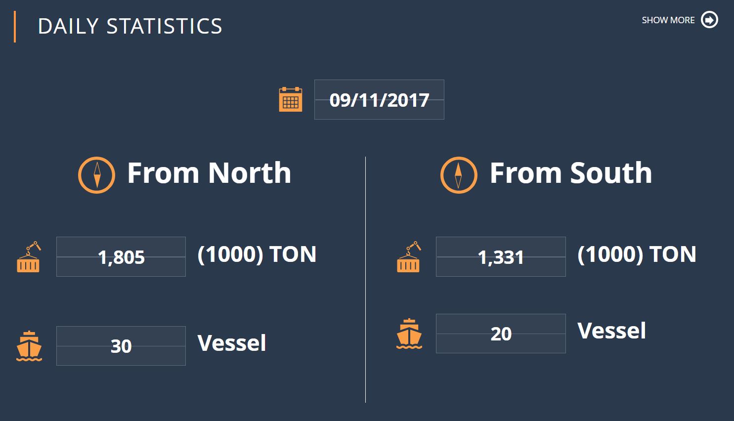
Some current stats of the use of the Suez.

Click photos for larger view. Oh BTW did I mention that the home-school students I teach on Fridays are my grandchildren?


Treasury of the Athenians at Delphi . . . More Background for Esther

September 20, 2017

The restored treasury of the Athenians at Delphi:

The Athenian Treasury was a votive building in the form of a reduced scale temple, designed to hold the multitude of Athenian offerings to the Delphi oracle. The building was constructed entirely of Parian marble and had a Doric frieze decorated with 30 metopes. It is a distyle in antis building with a porch before the entrance to the cella, measuring 10 x 6 meters.

The metopes depicted mythological themes of Theseus, Heracles, and Amazons in high relief. It is believed that two Athenian sculptors carved the metopes, each representing a distinct style or generation: one from the Archaic period, and one from the Severe style of classical art (the transition from Archaic to High Classical art). The walls of the treasury were inscribed with various texts, among which are the hymns to Apollo which included melody notation (see below).

Several dates for its construction have been suggested (with Pausanias mentioning that it was built after the battle of Marathon), but it is widely accepted that its was created sometime between 510 and 480 BCE, a period framed by the founding of the Athenian democracy and the defining battle of Marathon. (http://ancient-greece.org/museum/muse-delphi-athenians.html)

Delphi of course is “home of the famous oracle of Delphi, known as the Pythia, and the Temple of Apollo, where the oracle presided” (Fant, Clyde E.; Reddish, Mitchell G.. A Guide to Biblical Sites in Greece and Turkey, Kindle Locations 1180-1181).

Our photo here shows the treasury at left center:

Treasury of the Athenians at Delphi. Photo ©Leon Mauldin.

Regarding the famous battle of Marathon, 490 BC, where the greatly outnumbered Greeks repelled and defeated the Persians, EyeWitnessHistory.com has the following info:

The battle of Marathon is one of history’s most famous military engagements. It is also one of the earliest recorded battles. Their victory over the Persian invaders gave the fledgling Greek city states confidence in their ability to defend themselves and belief in their continued existence. The battle is therefore considered a defining moment in the development of European culture.

In September of 490 BC a Persian armada of 600 ships disgorged an invasion force of approximately 20,000 infantry and cavalry on Greek soil just north of Athens. Their mission was to crush the Greek states in retaliation for their support of their Ionian cousins who had revolted against Persian rule.

Undaunted by the numerical superiority of the invaders, Athens mobilized 10,000 hoplite warriors to defend their territory. The two armies met on the Plain of Marathon twenty-six miles north of Athens. The flat battlefield surrounded by hills and sea was ideal for the Persian cavalry. Surveying the advantage that the terrain and size of their force gave to the Persians, the Greek generals hesitated.

One of the Greek generals – Miltiades – made a passionate plea for boldness and convinced his fellow generals to attack the Persians. Miltiades ordered the Greek hoplites to form a line equal in length to that of the Persians. Then – in an act that his enemy believed to be complete madness – he ordered his Greek warriors to attack the Persian line at a dead run. In the ensuing melee, the middle of the Greek line weakened and gave way, but the flanks were able to engulf and slaughter the trapped Persians. An estimated 6,400 Persians were slaughtered while only 192 Greeks were killed.

The remaining Persians escaped on their ships and made an attempt to attack what they thought was an undefended Athens. However, the Greek warriors made a forced march back to Athens and arrived in time to thwart the Persians. (http://www.eyewitnesstohistory.com/pfmarathon.htm)

In our title I suggested that these events give further background to the biblical book of Esther. In our post here we showed how in 480 BC, ten years after the Battle of Marathon, the Persian King Xerxes was building his forces to again attempt to subjugate Greece. The fact that Persia was still “smarting” after her humiliating defeat by Greece helps us to see the purpose and even urgency behind those opening verses of Esther (1:1-9), where Xerxes is meeting with officials from his 127 provinces, which ranged from India to Ethiopia.

Click image for larger view.


Xerxes at Troy–Some Background for Esther

September 19, 2017

The events narrated in Esther take place during the reign of the Persian King Xerxes. “The Hebrew word used throughout the book is ʾaḥašwērôš (“Ahasuerus”) which is considered a variant of Xerxes’ name. Xerxes is the Greek form of the Persian Khshayârsha” (Huey, F. B., Jr., The Expositor’s Bible Commentary, Vol. 4, p. 797).

The book of Esther begins by telling of a great banquet in Susa, the capital,  in the 3rd year of his reign (483 BC): “in the third year of his reign he gave a banquet for all his princes and attendants, the army officers of Persia and Media, the nobles and the princes of his provinces being in his presence” (Esther 1:3). The biblical author’s intent was not to give the details as to the why of this banquet, but historical sources are helpful. Xerxes was on a mission to gather strength and support for his invasion [ill-fated] into Greece. This is the setting for the opening verses of Esther.

In the year 480 BC Xerxes marched westward to invade and attempt to conquer Greece. En route he passed through ancient Troy, where the historian Herodotus states, “he sacrificed a thousand heifers to Athene of Ilion” (Herodotus 7:43). Ilion is the Greek name for ancient Troy.

Our photo shows the Troy sanctuary area, Stratum VIII (dated ca. 700-85 BC).

Troy Sanctuary Area. Here Xerxes, King of Persia (r.486-464 BC) offered 1,000 heifers in sacrifice to the goddess Athena, in preparation for his war on Greece. Photo ©Leon Mauldin.

Xerxes’ invasion of Greece was a failure. It was after his return from his disappointing catastrophe that the Jewish maiden Esther became his queen, in the “seventh year of his reign” (Esther 2:17), which would be 479 BC.

Regarding the site in our photo above, Manfred O. Korfmann writes, “The earliest structures representing a sanctuary at the nearly deserted site are those established by the Aeolian Greeks sometime after 700 BCE, thus apparently existing within the lifetime of Homer! Votive offerings confirm the existence of much earlier sacred precincts as well” (TROİA/WIL̇USA p.62).

Of the city of Troy itself Korfmann continues, “Illion became the religious and political capital of a federation of municipalities, and to the south and east of the acropolis a lower city (on a grid-plan) arose – overtop and partially dug into remains from Trois VI/VII” (ibid.63).

The ancient city Troy consists of 46 occupational levels which date back to a total of nine different cities!

Our map shows Troy, which is a site on the Unesco World Heritage List.

Map of Troy in today’s Turkey, in relation to Greece.

I have previously posted on Troy here and here.

It is good to be reminded that the events of the Bible did not take place in a vacuum. The covenant people of God interacted with the people of their day, sometimes including the world powers as was the case in the Persian period, the setting for Esther.


Esther and the Providence of God

September 12, 2017

In our local congregation (Hanceville AL) we are soon to begin a study of Esther in our Sun AM class. I’m looking forward to this study, which displays the providence of God to continue, against all odds, to fulfill His plan through the Jewish people. The promise made to Abraham to bring salvation through the promised Seed, would be accomplished, in spite of the efforts of wicked Haman to destroy all the Jews of the Persian Empire.

Ladies at Şanlıurfa, or Urfa, Southeastern Turkey. Known in ancient times as Edessa. Photo ©Leon Mauldin.

The festive apparel of these ladies at Şanlıurfa perhaps help us visualize the dress of that ancient culture described in Esther.

Şanlıurfa, often simply known as Urfa or in Arabic, Al-Ruha, in ancient times was Edessa, located in south-eastern Turkey; it is the capital of Şanlıurfa Province. The city is populated with primarily Arabs, Kurds and Turks. Urfa is situated on a plain about 50 miles east of the Euphrates River.

Click image for larger view.


Signing the Covenant–Nehemiah 10

August 18, 2017

I love to study the book of Nehemiah. Jerusalem’s walls that had been in ruins since the Babylonian destruction (586 BC) were rebuilt (444 BC) in just 52 days! (Neh. 6:15). The people had a mind to work (4:6); they had a godly and capable leader in Nehemiah, and the good hand of God was upon them. But the remainder of the book (chapters 7ff.) is about the necessary follow-up; the necessary commitment to covenant faithfulness, without which the newly rebuilt walls would be meaningless.

Gezer Calendar. One of the oldest examples of Hebrew script. Istanbul Archaeological Museum. Photo by Leon Mauldin.

To that end Israel’s leaders/Levites promised God: “Now because of all this We are making an agreement in writing; And on the sealed document are the names of our leaders, our Levites and our priests” (Neh. 9:38). What follows is a listing of 84 names (Neh. 10:1-27). Nehemiah’s name appropriately is first.

The Gezer Calendar is one of the oldest examples of Hebrew script. We share it here to illustrate our Nehemiah text. Those men who signed their renewed covenant with God, as well as “the rest of the people” (10:28), were pledging themselves to obey (v.29) in their homes (v.30), their business (v.31) and worship (v.32). In short: “We will not neglect the house of our God” (v.39).

By the way, the Gezer Calendar in our photo is a school-boy’s exercise in learning the months of the year, associated with agricultural events.

Explanation of the Gezer Calendar. Photo by Leon Mauldin.

Click images for larger view.


Solomon’s Pools

August 16, 2017

On the day of Pentecost (Acts 2), for the first time conditions of salvation were proclaimed under the New Covenant. Three thousand responded!

“Therefore let all the house of Israel know for certain that God has made Him both Lord and Christ– this Jesus whom you crucified.” 37 Now when they heard this, they were pierced to the heart, and said to Peter and the rest of the apostles, “Brethren, what shall we do?” 38 Peter said to them, “Repent, and each of you be baptized in the name of Jesus Christ for the forgiveness of your sins; and you will receive the gift of the Holy Spirit. 39 “For the promise is for you and your children and for all who are far off, as many as the Lord our God will call to Himself.” 40 And with many other words he solemnly testified and kept on exhorting them, saying, “Be saved from this perverse generation!” 41 So then, those who had received his word were baptized; and that day there were added about three thousand souls. (vv. 36-41, NASB).

There were many pools right there in Jerusalem which would have been suitable for the baptism of so many, including the Pool of Siloam, the Pool(s) of Bethesda, etc. I am also mindful of “Solomon’s Pools,” south of Jerusalem, located between Bethlehem and Hebron, which were water sources for Jerusalem in the days of Jesus.

“Solomon’s Pool.” The middle of three. Photo by Leon Mauldin.

These three pools, the middle of which is in our photo here, were not built by Solomon, but by  Herod the Great, or possibly by the Hasmoneans (intertestamental period). Pilate later made repairs to the pools.

Today the pools are located in the Palestinian Authority’s West Bank.

Click photo for larger image.


Royal Tombs of the House of David

August 15, 2017

On the Day of Pentecost (Acts 2), which marked the beginning of the preaching of the Gospel and the discharge of the Great Commission, Peter affirmed the resurrection of the crucified Christ, showing the fulfillment of Psalm 16:8-11 (Acts 2:25-28). Peter explained,

Brethren, I may confidently say to you regarding the patriarch David that he both died and was buried, and his tomb is with us to this day. And so, because he was a prophet and knew that GOD HAD SWORN TO HIM WITH AN OATH TO SEAT one OF HIS DESCENDANTS ON HIS THRONE, he looked ahead and spoke of the resurrection of the Christ, that HE WAS NEITHER ABANDONED TO HADES, NOR DID His flesh SUFFER DECAY. This Jesus God raised up again, to which we are all witnesses (Acts 2:29-32, NASB). (Note: the NASB uses upper-case in NT texts to indicate quotations from the OT).

Here is the proposed site for the tombs of the house of David located at the SE portion of the City of David, excavated by Raymond Weill, 1913-1914.

Royal Tombs of the House of David, proposed site. Photo by Leon Mauldin.

And a close-up shot:

Proposed Tomb of the House of David. Photo by Leon Mauldin.

Dr. Todd Bolen notes,

Most scholars today reject this identification. These structures do not have features typical of Iron Age tombs; there are no burial benches or repositories. Because of later destruction, there is no stratigraphy, pottery, or burial gifts which would make dating the structure possible. Some scholars think that it dates to the Herodian period and may have been used as wine cellars for the structures built above it. There is no other candidate for the tomb of David.

The point to be remembered is that unlike the Subject of David’s psalm, David was buried, and his body saw corruption. The One of Whom he spoke saw no corruption. His body did not decay, and His spirit was not left in the Hadean realm–up from the grave He arose! The resurrection of Jesus is at the very heart of the Gospel message. Apart from the resurrection of Jesus there IS no Gospel!

We recently wrote on David’s Tomb here.

Click images for larger view.


Akeldama, the Field of Blood (Acts 1)

August 9, 2017

The Bible tells us of Judas’ remorse and subsequent suicide after his betrayal of Jesus (Matt. 27:3-10). Afterward the book of Acts continues with the selection of an apostle to take the place of Judas. To lead into that topic Peter reviewed what had happened:

“Brothers, the Scripture had to be fulfilled, which the Holy Spirit spoke beforehand by the mouth of David concerning Judas, who became a guide to those who arrested Jesus. For he was numbered among us and was allotted his share in this ministry.”  (Now this man bought a field with the reward of his wickedness, and falling headlong he burst open in the middle and all his bowels gushed out. And it became known to all the inhabitants of Jerusalem, so that the field was called in their own language Akeldama, that is, Field of Blood.)  “For it is written in the Book of Psalms, “‘ May his camp become desolate, and let there be no one to dwell in it’; and “‘Let another take his office.'” (Acts 1:16-20).

Akeldama, south of Jerusalem. Photo by Leon Mauldin.

Our photo shows the traditional site of Akeldama at center, just beyond the valley. This is the area were the Kidron and Hinnom valleys converge. The structure you see is a Greek Orthodox Monastery, built in 1874, named after Onuphrius, an Egyptian anchorite known for the length of his beard.

Leen & Kathleen Ritmeyer note:

This area was identified as Akeldama as early as the third and fourth centuries. The earliest chroniclers—Eusebius, who visited the land in 335 A.D., among whose writings was a life of the Emperor Constantine, and Jerome, 400 A.D., the author of an onomasticon (a list of proper names, which sought to locate sites hallowed by Scripture)—both identify this place with confidence as the Field of Blood referred to in the New Testament. In 570 A.D., the pilgrim Antoninus made the same identification. (1994). BAR, 20(6).

Even so, the Ritmeyers think this site to be implausible as the Field of Blood, because “here are some of the most splendid Herodian tombs ever discovered” . . . “a field of elegant and elegantly decorated burial caves.” “One of them probably belonged to the high priest Annas” (Ibid.).

Click photo for larger view.


“I Was the King’s Cupbearer” (Nehemiah)

July 20, 2017

Nehemiah, whom God used to rebuild the walls of Jerusalem (444 BC), served during the administration of the Persian King Artaxerxes (464-423 BC). Nehemiah states, “For I was the king’s cupbearer” (Nehemiah 1:11).

Drinking Cup. Bible Lands Museum, Jerusalem. Photo by Leon Mauldin.

Professor Edwin Yamauchi has some helpful information on what it would have meant to be a “cupbearer”:

“Cupbearer” (mašqeh is a Hiphil participle of the verb šaqāh) literally means “one who gives (someone) something to drink.” It occurs twelve times in the OT in the sense of “cupbearer,” e.g., in 1 Kings 10:5 and 2 Chronicles 9:4 of Solomon’s attendants. In the Joseph story it occurs nine times (Gen 40:1–41:9), but its significance is obscured by the KJV and the RSV, which translate the word “butler.” That the cupbearer could have other responsibilities as well is indicated by Tobit 1:22: “Now Ahikar was cupbearer, keeper of the signet, and in charge of administration of the accounts, for Esarhaddon had appointed him second to himself.” For archaeological evidence of Persian wine services, see P.R.S. Moorey, “Metal Wine-Sets in the Ancient Near East,” Iranica Antiqua 15 (1980): 181ff.
Varied sources suggest something about Nehemiah as a royal cupbearer:

1. He would have been well-trained in court etiquette (cf. Dan 1:4–5).

2. He was probably a handsome individual (cf. Dan 1:4, 13, 15; Jos. Antiq. XVI, 230 [viii.1]).

3. He would certainly know how to select the wines to set before the king. A proverb in the Babylonian Talmud (Baba Qamma 92b) states: “The wine belongs to the master but credit for it is due to his cupbearer.”

4. He would have to be a convivial companion, willing to lend an ear at all times.

5. He would have great influence as one with the closest access to the king, able to determine who was able see his master.

6. Above all Nehemiah had to be one who enjoyed the unreserved confidence of the king. The great need for trustworthy court attendants is underscored by the intrigues endemic to the Achaemenid court. Xerxes, father of Artaxerxes I, was killed in his own bedchamber by Artabanus, a courtier (The Expositor’s Bible Commentary: 1 & 2 Kings, 1 & 2 Chronicles, Ezra, Nehemiah, Esther, Job. Vol. 4, p. 683).

H.G.M. Williamson notes:

Royal cupbearers in antiquity, in addition to their skill in selecting and serving wine and their duty in tasting it as proof against poison, were also expected to be convivial and tactful companions to the king. Being much in his confidence, they could thus wield considerable influence by way of informal counsel and discussion. Texts and pictures from many Ancient Near Eastern sources (including Achaemenid) supporting this statement have been helpfully collected by Yamauchi, ZAW 92 (1980) 132–42. The portrayal fits admirably with the sequel in chap. 2. It may be noted also that the office of cupbearer could be combined with other important offices. (Word Biblical Commentary, Ezra, Nehemiah. Vol. 16, p. 174).

Click image for larger view.


The Euphrates, at Zeugma/Seleucia

June 20, 2017

We are currently teaching the OT book of Ezra in our local congregation. Ezra 8 mentions Ahava as a place (v.15) and a river (note NET: “canal” and NLT: “Ahava Canal” (vv.21,31).

This [Ahava] has not been identified, though it appears from v 21 that both the canal (lit., “river”) and the locality shared the same name. We must assume from the context that it was a large open space close to Babylon. Babylon itself was built on the Euphrates river from which flowed a number of artificial canals and waterways for defensive purposes (cf. IDB 1, 334–38; Ezek 1:1; Ps 137:1). Ahava was no doubt one of these (Williamson, H. G. M. Ezra, Nehemiah, Word Biblical Commentary, p. 116).

Our photo shows the Euphrates at Zeugma, named Selucia during the Grecian intertestamental period.

Euphrates River at Zeugma. Photo by Leon Mauldin.

I took this photo in Upper Mesopotamia, near the Birecik Dam, well north of the area referenced in Ezra 8, but it serves well for illustrative purposes. In the foreground are pistachio trees.

Pistachio tree, close-up. Photo by Leon Mauldin.

Originally, the ancient city of Zeugma was founded as a Greek settlement by Seleucus I Nicator, one of the generals of Alexander the Great, in 300 BC. The city was called “Zeugma”, because of the bridge across the Euphrates River that was made of pontoons, thus connecting the two banks of the river. In Greek, “zeugma” means “bridge-passage” or “bridge of boats”. The population of the city at its peak was approximately 80,000.

In 64 BC the city was conquered and ruled by the Roman Empire. During Roman rule, the city became one of the attractions in the region, due to its commercial potential originating from its geo-strategic location because the city was on the Silk Road connecting Antioch to China via a bridge of pontoons across the river Euphrates, which defined the border with the Persian Empire until the late 2nd century.

In 256 AD, Zeugma experienced an invasion and was destroyed by the Sassanid king, Shapur I. The damage from the invasion was so drastic that Zeugma was not able to recover for a long time. To make the situation even worse, a violent earthquake buried the city beneath rubble. Indeed, during the rest of its time under Roman rule, the city never regained the prosperity it had once achieved.

Zeugma and environs remained part of the Roman empire. During the 5th and 6th centuries the city was ruled by the Early Byzantium or Eastern Roman Empire. As a result of the ongoing Arab raids the city was abandoned once again. Later on, in the 10th and 12th centuries, a small Abbasid group settled in Zeugma.

Finally a village called Belkis was founded at the site in the 17th century. (Wikipedia).

To see another of my photos of the Euphrates click here. Ferrell Jenkins has several entries on the Euphrates including here and here.

Click images for larger view.