Solomon Went to Elath

October 30, 2023

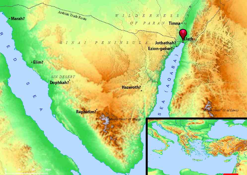
“Then Solomon went to Ezion Geber and Elath on the coast of Edom. And Hiram sent him ships commanded by his own officers, men who knew the sea. These, with Solomon’s men, sailed to Ophir and brought back four hundred and fifty talents of gold, which they delivered to King Solomon (2 Chronicles 8:17,18).

Let’s first get the geographical setting of Elath (also spelled Eloth, Eilat):

Map courtesy of biblemapper.com

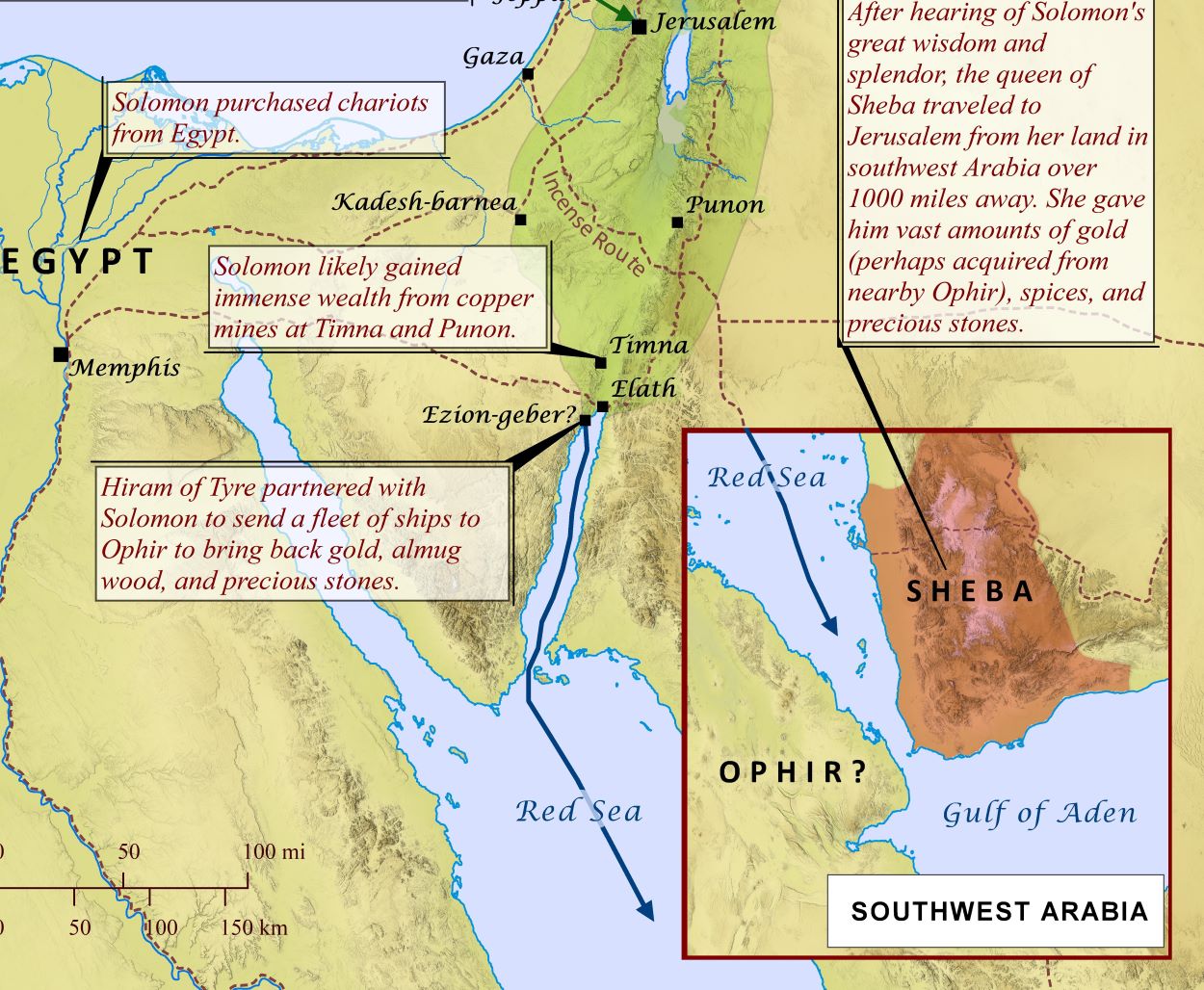
The location of Elath was at the southern tip of the Arabah, and the north eastern tip of the Red Sea, at the Gulf of Aqaba. This allowed Solomon’s fleet of ships access to the Red Sea and of course, south from there into the Indian Ocean. It would seem that through this means of commerce the Queen of Sheba (see map inset) learned of Solomon, and made the journey to see for herself the incredible reports she had heard (related in the next chapter, 2 Chron. 9:1-12).

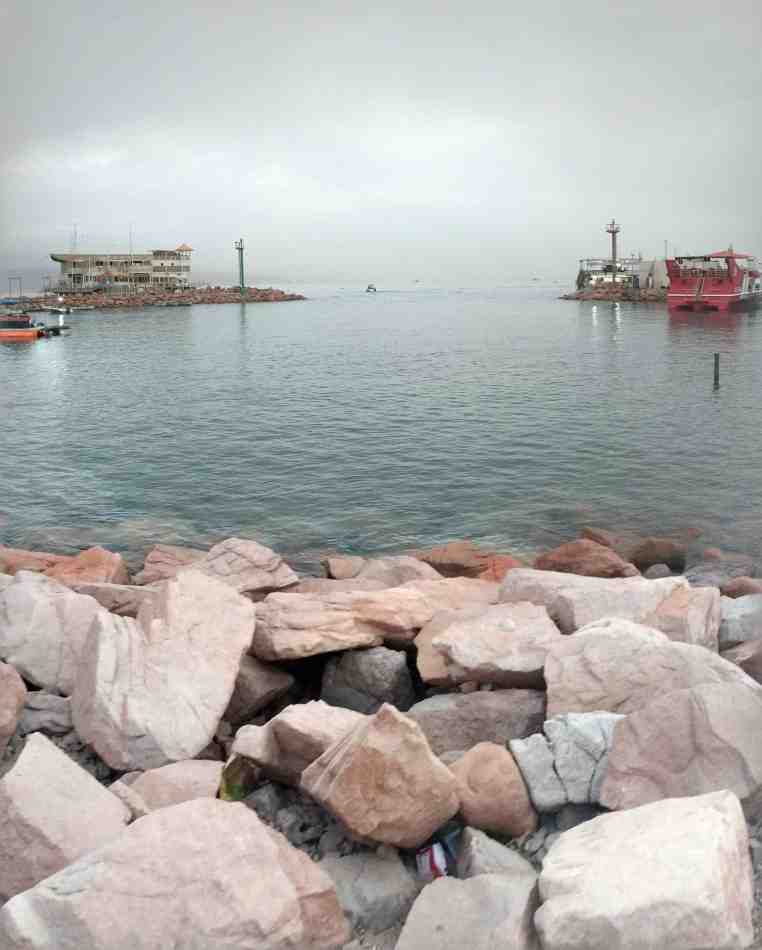
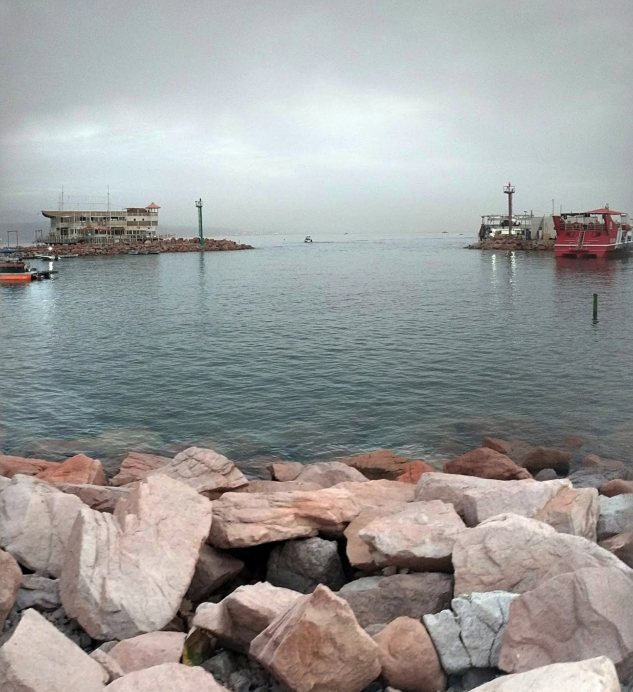
In March 2018, Ferrell Jenkins and I made a personal study trip which included this area. In this photo I am at Elath looking south.

At Elath, looking south. Photo ©Leon Mauldin.

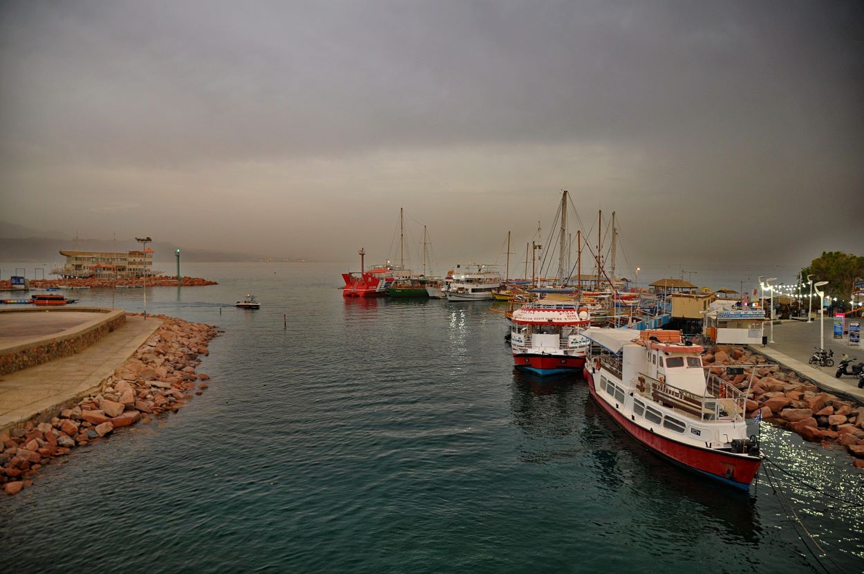
Here we see a view showing some ships at Elath.

Ships in harbor at Elath. Photo ©Leon Mauldin.

B. S. Hummel has the following information regarding Elath:

A city and harbor at the head of the Gulf of Aqabah. Elath’s strategic position made it an important gateway for caravan and naval commerce with Arabia and eastern Africa. In the OT Elath is frequently placed in close proximity to Ezion-geber. Some scholars consider Tell el-Kheleifeh (147884), which lies between modern Elath and Aqabah, as Elath, others as Ezion-geber, and still others as the site for both Elath and Ezion-geber. The site was also known as El-paran (Gen. 14:6). The Ptolemies changed its name to Bernice.
Elath was originally Edomite, possibly taking its name from the Edomite chief Elah (Gen. 36:41 = 1 Chr. 1:52; Eloth). Toward the end of the Exodus, the Israelites passed through Elath before turning north toward Edom and Moab (Deut. 2:8). David probably captured it during his campaign against the Edomites (2 Sam. 8:13–14). Solomon then established a navy of ships in Ezion-geber near Elath (1 Kgs. 9:26 = 2 Chr. 8:17). Apparently the Edomites had regained control, but Uzziah (Azariah, 2 Kgs. 14:22; 2 Chr. 26:2) recaptured and restored it (ca. 780 B.C.). However, under Aramean (Syrian) pressure during the Syro-Ephraimite War (ca. 735), Ahaz lost it to the Edomites permanently (2 Kgs. 16:6).

Hummel, B. S. (2000). Elath. In D. N. Freedman, A. C. Myers, & A. B. Beck (Eds.), Eerdmans Dictionary of the Bible (p. 388). W.B. Eerdmans.

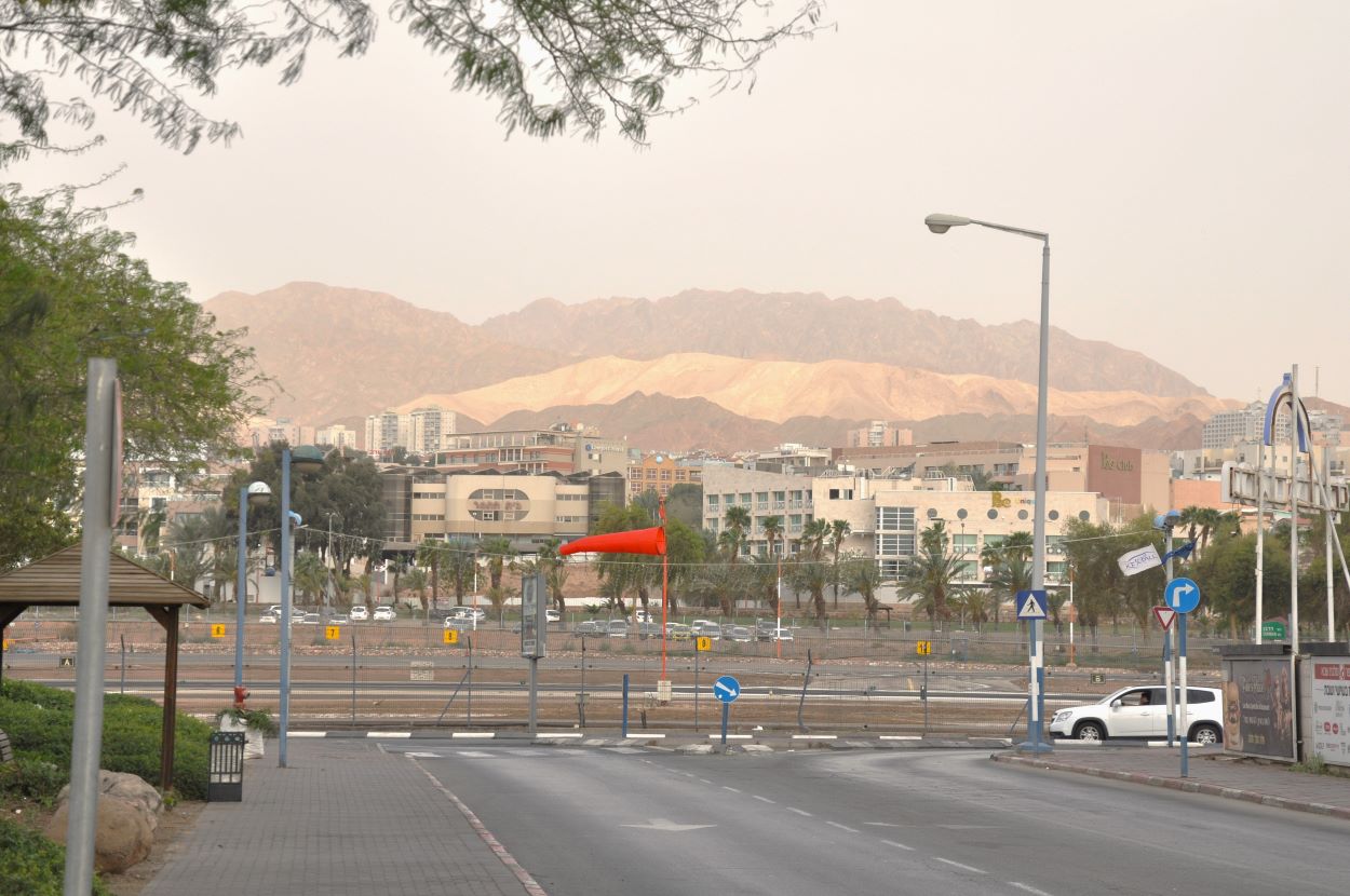
At Elath, looking east. We are of course in the Great Rift Valley here.

At Elath, looking at mountains to the east. Photo ©Leon Mauldin.

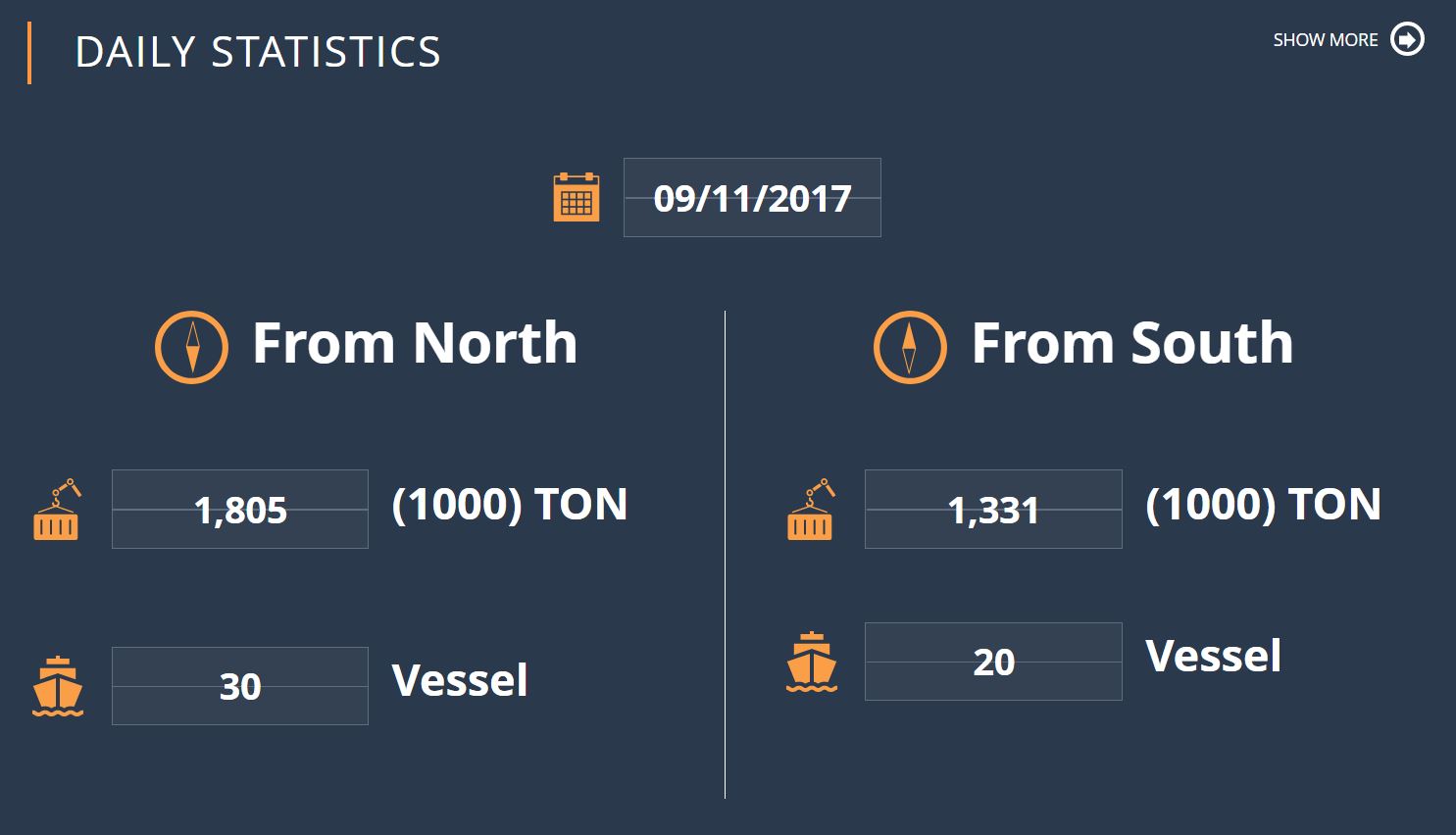
The Port of Elath/Eilat (Hebrew: נמל אילת) is the only Israeli port on the Red Sea.


At Biblical Elath, on the Red Sea

March 27, 2018

The past two days Ferrell Jenkins and I have explored various sites in the Arabah (see Deut. 1:1 & etc., NASB), using Elath (spellings vary) as our base. This evening I took a photo looking out to the Red Sea.

Looking out to the Red Sea from Elath. Photo by Leon Mauldin.

It was in this area that King Solomon stationed a fleet of ships: “King Solomon also built a fleet of ships at Ezion Geber, which is near Elath on the shore of the Red Sea, in the land of Edom” (1 Kings 9:26).  This was made possible through the cooperation of the Phoenicians. 2 Chronicles 8 records, “Then Solomon went to Ezion Geber and Elath on the seacoast, in the land of Edom. And Hiram sent him ships by the hand of his servants, and servants who knew the sea. They went with the servants of Solomon to Ophir, and acquired four hundred and fifty talents of gold from there, and brought it to King Solomon” (vv.17-18).

Note the location of Elath:

Location of Elath on the Red Sea. BibleAtlas.com.

Click images for larger view.


The Suez Canal

November 10, 2017

On most Friday afternoons I teach some homeschoolers (brilliant students) two subjects, Bible and History. Currently their world history is dealing with the 19th century. One of the topics in that time-frame is the construction of the Suez Canal. Said Pasha  gave a concession to Ferdinand de Lesseps who created a French company, The Suez Canal Company, to join the Mediterranean Sea with the Red Sea. The canal opened under French control on November 17, 1869. (Said was Wāli of Egypt and Sudan from 1854 until 1863, officially owing allegiance to the Ottoman Sultan but in practice exercising virtual independence. 4th son of Muhammad Ali Pasha).

The Suez Canal. The Sinai Peninsula is at our back, looking across to Egypt. Photo ©Leon Mauldin.

Our text says:

Naturally, the countries of Europe were very interested in this canal–the Suez Canal. The canal could change the way that European countries traded with China, Japan, and the other countries of the Far East. Instead of travelling all the way down the coast of Africa, around the tip of that enormous continent, and then heading east, European ships could sail from the Mediterranean Sea straight down into the Red Sea and then turn east. When the canal was finished,it would be a hundred miles long, about twenty-six feet deep, and it would make the trip from Europe to the  East six thousand miles shorter! (The Story of the World: History for the Classical Child. Vol.4, p. 109).

This area is of tremendous biblical importance as it pertains to Israel’s crossing of the Red Sea en route to the promised land of Canaan. I have previously written here and here on the Suez.

Another view of the Suez. Photo ©Leon Mauldin.

The canal separates the African continent from Asia, and it provides the shortest maritime route between Europe and the lands lying around the Indian and western Pacific oceans. It is one of the world’s most heavily used shipping lanes. The Suez Canal is one of the most important waterways in the world.

The canal is extensively used by modern ships , as it is the fastest crossing from the Atlantic Ocean to the Indian Ocean . Tolls paid by the vessels represent an important source of income for the Egyptian government.

Railway and a sweet water canal are run on the west bank parallel to the Suez Canal. The Canal runs between Port Said harbor and the Gulf of Suez, through soils which vary according to the region. At Port Said and the surrounding area, the soil is composed over thousands of years of silt and clay sedimentations deposited by the Nile waters drifted by Damietta branch. This formation extends to Kantara, 40 km to the south of Port Said , where silt mixes with sand. The central region of the Canal between Kantara and Kabret consists of fine and coarse sands, while the southern region contains dispersed layers of rocks, varying in texture from soft sand to some calcium rocks, The side gradient of the water cross-section differs according to the nature of the soil, which is 4:1 in the north and 3:1 in the south.

The Suez Canal is a sea level Canal and the height of water level differs slightly and the extreme tidal range is 65 cm in the north and 1.9 m in the south. The banks of the Canal are protected against the wash and waves, generated by the transit of ships, by revetments of hard stones and steel sheet piles corresponding to the nature of soil in every area. On both sides of the Canal, there are mooring bollards every 125 m for the mooring of vessel in case of emergency, and kilometric sign posts helping locate the position of ships in the waterway. The navigable channel is bordered by light and reflecting buoys as navigational aids to night traffic. (http://www.suezcanal.gov.eg).

Some current stats of the use of the Suez.

Click photos for larger view. Oh BTW did I mention that the home-school students I teach on Fridays are my grandchildren?